Castaic night lights from space
Night Light of Castaic (California) from space (United States) Src. Average luminocity for 10x10km area is 42.4091% and for 50x50km: 19.584%.
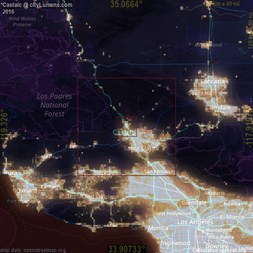
Analysis of Castaic night lights 2016
Square area 10x10 km:
 5.42%
5.42%90-99
6.29%80-89
3.15%70-79
3.32%60-69
11.36%50-59
9.97%40-49
9.79%30-39
8.74%20-29
7.34%10-19
20.45%0-9
14.16%Square area 50x50 km:
3.01%90-99
3.84%80-89
1.72%70-79
2.41%60-69
4.26%50-59
3.14%40-49
3.11%30-39
3.38%20-29
4.17%10-19
7.04%0-9
63.92%Clear (daylight) street map image can be seen on geolist.org.
Map coordinates:
35° 3' 59" North, 119° 19' 33.6" West
34° 29' 20" North, 118° 37' 22.3" West
33° 54' 26.4" North, 117° 55' 11.1" West
Some cities around Castaic sort by population:
• Santa Clarita
13.1 km =8.1 mi,  145°
145°
• Valencia
5.2 km =3.2 mi,  166°
166°
• Simi Valley
28.4 km =17.6 mi,  210°
210°
• Northridge
30 km =18.6 mi,  164°
164°
• Chatsworth
25.8 km =16 mi,  175°
175°
• San Fernando
28.5 km =17.7 mi,  143°
143°
• Stevenson Ranch
11.8 km =7.3 mi, 157°
• Fillmore
28.9 km =18 mi,  249°
249°
5334799 (p: 19,015)
Sources (retrieved 2019-11-25):
» Earth at Night: Flat Maps 2012, 2016