Chatsworth night lights from space
Night Light of Chatsworth (California) from space (United States) Src. Average luminocity for 10x10km area is 71.9176% and for 50x50km: 50.591%.
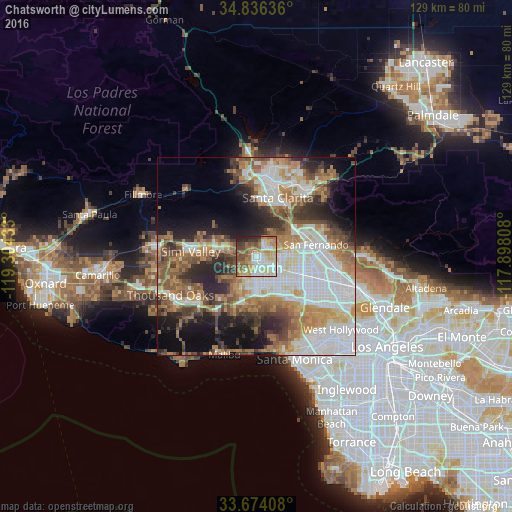

Analysis of Chatsworth night lights 2016
Square area 10x10 km:
 15.75%
90-99
13.92%80-89
13.37%70-79
11.72%60-69
16.3%50-59
10.62%40-49
7.33%30-39
4.95%20-29
4.95%10-19
1.1%0-9
0%Square area 50x50 km:
13.64%90-99
9.76%80-89
4.67%70-79
6.2%60-69
9.63%50-59
7.41%40-49
6.23%30-39
5.59%20-29
8.25%10-19
10.22%0-9
18.4%Clear (daylight) street map image can be seen on geolist.org.
Map coordinates:
34° 50' 10.9" North, 119° 18' 15.6" West
34° 15' 26" North, 118° 36' 4.3" West
33° 40' 26.7" North, 117° 53' 53.1" West
Some cities around Chatsworth sort by population:
• Woodland Hills
9.9 km =6.2 mi,  182°
182°
• Northridge
6.7 km =4.2 mi,  118°
118°
• Canoga Park
6.2 km =3.9 mi, 177°
• North Hills
11 km =6.8 mi,  102°
102°
• Encino
14.3 km =8.9 mi,  139°
139°
• West Hills
7.7 km =4.8 mi,  210°
210°
• Calabasas
11.6 km =7.2 mi,  197°
197°
• Stevenson Ranch
15 km =9.3 mi,  9°
9°
5336054 (p: 41,255)
Sources (retrieved 2019-11-25):
» Earth at Night: Flat Maps 2012, 2016