Henderson night lights from space
Night Light of Henderson (Texas) from space (United States) Src. Average luminocity for 10x10km area is 43.8986% and for 50x50km: 5.5805%.
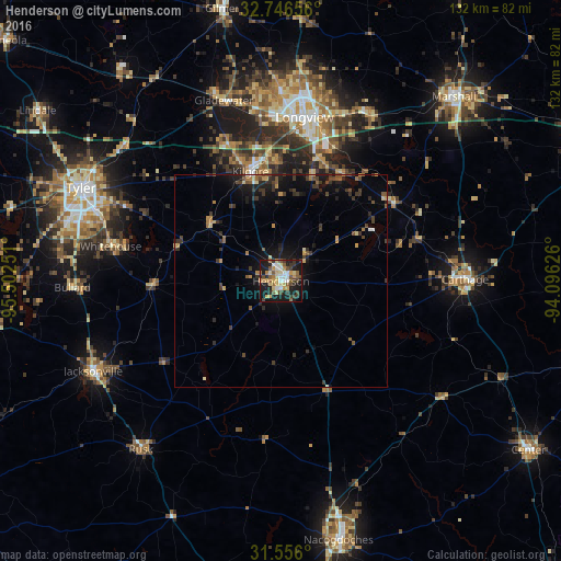
Analysis of Henderson night lights 2016
Square area 10x10 km:
 4.72%
4.72%90-99
5.59%80-89
8.39%70-79
8.22%60-69
5.24%50-59
7.69%40-49
6.29%30-39
8.39%20-29
8.22%10-19
33.39%0-9
3.85%Square area 50x50 km:
0.25%90-99
0.35%80-89
0.64%70-79
0.84%60-69
0.61%50-59
0.92%40-49
1.03%30-39
1.76%20-29
1.35%10-19
4.85%0-9
87.39%Clear (daylight) street map image can be seen on geolist.org.
Map coordinates:
32° 44' 47.6" North, 95° 30' 9" West
32° 9' 11.6" North, 94° 47' 57.8" West
31° 33' 21.6" North, 94° 5' 46.5" West
Some cities around Henderson sort by population:
• Longview
39 km =24.2 mi,  8°
8°
• Kilgore
26.9 km =16.7 mi,  344°
344°
• Jacksonville
49.1 km =30.5 mi,  244°
244°
• Whitehouse
40.9 km =25.4 mi,  281°
281°
• Carthage
43.5 km =27 mi,  89°
89°
• Gladewater
44.7 km =27.8 mi, 342°
• White Oak
42.1 km =26.2 mi,  352°
352°
• Rusk
51.7 km =32.1 mi,  219°
219°
4046332 (p: 13,529)
Sources (retrieved 2019-11-25):
» Earth at Night: Flat Maps 2012, 2016