Carpinteria night lights from space
Night Light of Carpinteria (California) from space (United States) Src. Average luminocity for 10x10km area is 15.0944% and for 50x50km: 6.058%.
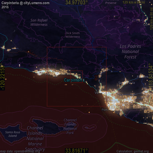
Analysis of Carpinteria night lights 2016
Square area 10x10 km:
 0%
0%90-99
0.35%80-89
2.1%70-79
2.8%60-69
3.67%50-59
3.85%40-49
4.02%30-39
1.92%20-29
0.35%10-19
3.5%0-9
77.45%Square area 50x50 km:
0.31%90-99
0.54%80-89
0.29%70-79
0.71%60-69
1.28%50-59
1.25%40-49
1.89%30-39
0.98%20-29
1.51%10-19
4.94%0-9
86.3%Clear (daylight) street map image can be seen on geolist.org.
Map coordinates:
34° 58' 37.3" North, 120° 13' 17.7" West
34° 23' 56" North, 119° 31' 6.5" West
33° 49' 0.2" North, 118° 48' 55.2" West
Some cities around Carpinteria sort by population:
• Ventura
24.6 km =15.3 mi,  122°
122°
• Santa Barbara
16.7 km =10.4 mi,  278°
278°
• Goleta
28.7 km =17.8 mi, 278°
• Isla Vista
31.5 km =19.6 mi,  272°
272°
• Montecito
11.2 km =7 mi,  291°
291°
• Ojai
25.9 km =16.1 mi,  77°
77°
• El Rio
37.3 km =23.2 mi, 119°
• Mira Monte
21.7 km =13.5 mi, 79°
5334423 (p: 13,727)
Sources (retrieved 2019-11-25):
» Earth at Night: Flat Maps 2012, 2016