Cape Canaveral night lights from space
Night Light of Cape Canaveral (Florida) from space (United States) Src. Average luminocity for 10x10km area is 34.8373% and for 50x50km: 18.3414%.
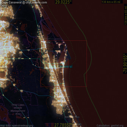
Analysis of Cape Canaveral night lights 2016
Square area 10x10 km:
 6.75%
6.75%90-99
5.56%80-89
0.79%70-79
1.98%60-69
10.71%50-59
1.59%40-49
1.19%30-39
3.57%20-29
20.24%10-19
35.52%0-9
12.1%Square area 50x50 km:
1.66%90-99
2.01%80-89
1.06%70-79
2.07%60-69
7.35%50-59
2.6%40-49
2.71%30-39
3.45%20-29
6.3%10-19
9.67%0-9
61.12%Clear (daylight) street map image can be seen on geolist.org.
Map coordinates:
29° 1' 21" North, 81° 18' 28.4" West
28° 24' 21" North, 80° 36' 17.2" West
27° 47' 8.1" North, 79° 54' 5.9" West
Some cities around Cape Canaveral sort by population:
• Merritt Island
16.2 km =10.1 mi,  336°
336°
• Rockledge
13.3 km =8.3 mi,  242°
242°
• Cocoa
13.6 km =8.5 mi,  260°
260°
• Port Saint John
19.6 km =12.2 mi,  293°
293°
• Cocoa Beach
9.5 km =5.9 mi,  182°
182°
• Viera East
19.2 km =11.9 mi,  213°
213°
• Viera West
21.9 km =13.6 mi,  215°
215°
• Cocoa West
17.1 km =10.6 mi,  252°
252°
4149959 (p: 9,912)
Sources (retrieved 2019-11-25):
» Earth at Night: Flat Maps 2012, 2016