Cocoa Beach night lights from space
Night Light of Cocoa Beach (Florida) from space (United States) Src. Average luminocity for 10x10km area is 26.498% and for 50x50km: 20.1747%.
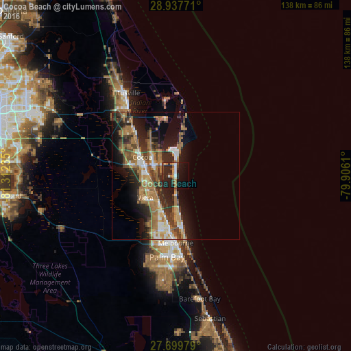
Analysis of Cocoa Beach night lights 2016
Square area 10x10 km:
 2.58%
2.58%90-99
2.98%80-89
2.38%70-79
1.98%60-69
6.35%50-59
1.39%40-49
2.18%30-39
6.55%20-29
15.28%10-19
30.36%0-9
27.98%Square area 50x50 km:
1.92%90-99
2.47%80-89
1.48%70-79
2.43%60-69
7.41%50-59
2.99%40-49
2.97%30-39
3.81%20-29
6.34%10-19
10.41%0-9
57.78%Clear (daylight) street map image can be seen on geolist.org.
Map coordinates:
28° 56' 15.8" North, 81° 18' 44.5" West
28° 19' 14" North, 80° 36' 33.2" West
27° 41' 59.2" North, 79° 54' 22" West
Some cities around Cocoa Beach sort by population:
• Rockledge
11.9 km =7.4 mi,  286°
286°
• Port Saint John
24.7 km =15.3 mi,  314°
314°
• Viera East
12.2 km =7.6 mi,  237°
237°
• Satellite Beach
16.2 km =10.1 mi,  173°
173°
• Cape Canaveral
9.5 km =5.9 mi,  2°
2°
• Indian Harbour Beach
19.2 km =11.9 mi, 173°
• Viera West
14.8 km =9.2 mi, 235°
• South Patrick Shores
13.2 km =8.2 mi,  180°
180°
4151441 (p: 11,595)
Sources (retrieved 2019-11-25):
» Earth at Night: Flat Maps 2012, 2016