Cocoa West night lights from space
Night Light of Cocoa West (Florida) from space (United States) Src. Average luminocity for 10x10km area is 60.0794% and for 50x50km: 19.6557%.
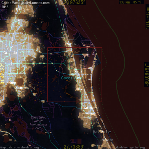
Analysis of Cocoa West night lights 2016
Square area 10x10 km:
 9.92%
9.92%90-99
16.07%80-89
2.78%70-79
4.76%60-69
20.24%50-59
7.94%40-49
12.5%30-39
8.53%20-29
6.94%10-19
8.53%0-9
1.79%Square area 50x50 km:
1.69%90-99
2.12%80-89
1.23%70-79
2.3%60-69
7.69%50-59
2.91%40-49
2.93%30-39
3.72%20-29
6.5%10-19
10.66%0-9
58.26%Clear (daylight) street map image can be seen on geolist.org.
Map coordinates:
28° 58' 34.9" North, 81° 28' 27.2" West
28° 21' 33.9" North, 80° 46' 15.9" West
27° 44' 20" North, 80° 4' 4.7" West
Some cities around Cocoa West sort by population:
• Merritt Island
22.2 km =13.8 mi,  25°
25°
• Rockledge
4.6 km =2.9 mi,  102°
102°
• Port Saint John
13.2 km =8.2 mi,  352°
352°
• Viera East
12.1 km =7.5 mi,  152°
152°
• Satellite Beach
27 km =16.8 mi,  138°
138°
• Cape Canaveral
17.1 km =10.6 mi,  72°
72°
• Viera West
13.2 km =8.2 mi,  163°
163°
• South Patrick Shores
23.6 km =14.7 mi, 137°
7260057 (p: 5,925)
Sources (retrieved 2019-11-25):
» Earth at Night: Flat Maps 2012, 2016