Cañon City night lights from space
Night Light of Cañon City (Colorado) from space (United States) Src. Average luminocity for 10x10km area is 31.3604% and for 50x50km: 2.8%.
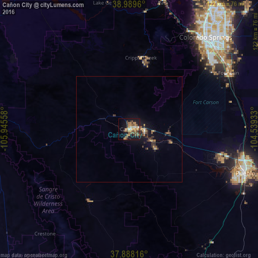
Analysis of Cañon City night lights 2016
Square area 10x10 km:
 1.46%
1.46%90-99
2.6%80-89
5.19%70-79
6.66%60-69
5.03%50-59
9.25%40-49
5.52%30-39
4.55%20-29
3.08%10-19
28.9%0-9
27.76%Square area 50x50 km:
0.13%90-99
0.15%80-89
0.34%70-79
0.5%60-69
0.33%50-59
0.66%40-49
0.48%30-39
0.74%20-29
0.48%10-19
2.7%0-9
93.5%Clear (daylight) street map image can be seen on geolist.org.
Map coordinates:
38° 59' 22.6" North, 105° 56' 44.1" West
38° 26' 27.5" North, 105° 14' 32.8" West
37° 53' 17.4" North, 104° 32' 21.6" West
Some cities around Cañon City sort by population:
• Colorado Springs
57 km =35.4 mi,  39°
39°
• Pueblo
59 km =36.7 mi,  110°
110°
• Security-Widefield
57.1 km =35.5 mi,  53°
53°
• Pueblo West
46.4 km =28.8 mi,  102°
102°
• Fountain
54.2 km =33.7 mi,  60°
60°
• Fort Carson
51.4 km =31.9 mi, 50°
• Stratmoor
54.7 km =34 mi, 47°
• Manitou Springs
54.5 km =33.9 mi,  31°
31°
5416005 (p: 16,400)
Sources (retrieved 2019-11-25):
» Earth at Night: Flat Maps 2012, 2016