Countryside night lights from space
Night Light of Countryside (Virginia) from space (United States) Src. Average luminocity for 10x10km area is 72.6818% and for 50x50km: 49.0745%.
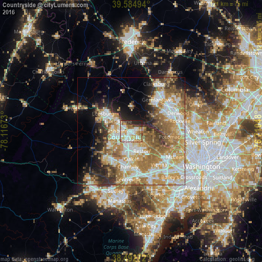
Analysis of Countryside night lights 2016
Square area 10x10 km:
 20.13%
90-99
20.94%80-89
7.31%70-79
15.42%60-69
9.25%50-59
3.57%40-49
2.27%30-39
6.01%20-29
11.69%10-19
3.41%0-9
0%Square area 50x50 km:
10.06%90-99
10.38%80-89
6.59%70-79
9.64%60-69
9.44%50-59
6.3%40-49
4.29%30-39
4.79%20-29
6.02%10-19
7.66%0-9
24.84%Clear (daylight) street map image can be seen on geolist.org.
Map coordinates:
39° 35' 5.8" North, 78° 7' 0.2" West
39° 2' 27.4" North, 77° 24' 49" West
38° 29' 33.8" North, 76° 42' 37.7" West
Some cities around Countryside sort by population:
• Ashburn
6.4 km =4 mi,  272°
272°
• Sterling
4.1 km =2.5 mi,  198°
198°
• Herndon
8.3 km =5.2 mi,  163°
163°
• Broadlands
9.6 km =6 mi,  254°
254°
• Dranesville
7.4 km =4.6 mi,  127°
127°
• Sugarland Run
3.3 km =2.1 mi,  96°
96°
• Lowes Island
5.7 km =3.5 mi,  68°
68°
• Belmont
8.7 km =5.4 mi,  287°
287°
4754219 (p: 10,072)
Sources (retrieved 2019-11-25):
» Earth at Night: Flat Maps 2012, 2016