Brainerd night lights from space
Night Light of Brainerd (Minnesota) from space (United States) Src. Average luminocity for 10x10km area is 38.2857% and for 50x50km: 2.3487%.
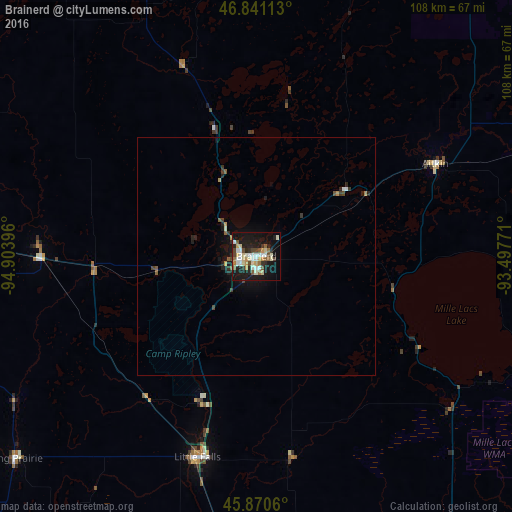
Analysis of Brainerd night lights 2016
Square area 10x10 km:
 5.8%
5.8%90-99
9.38%80-89
5.36%70-79
4.46%60-69
3.87%50-59
3.87%40-49
4.61%30-39
1.79%20-29
11.31%10-19
34.82%0-9
14.73%Square area 50x50 km:
0.26%90-99
0.41%80-89
0.22%70-79
0.28%60-69
0.21%50-59
0.3%40-49
0.35%30-39
0.23%20-29
0.77%10-19
2.19%0-9
94.76%Clear (daylight) street map image can be seen on geolist.org.
Map coordinates:
46° 50' 28.1" North, 94° 54' 14.3" West
46° 21' 28.9" North, 94° 12' 3" West
45° 52' 14.2" North, 93° 29' 51.8" West
Some cities around Brainerd sort by population:
• Saint Cloud
88.7 km =55.1 mi,  178°
178°
• Sartell
81.9 km =50.9 mi, 180°
• Sauk Rapids
85.2 km =52.9 mi, 178°
• Alexandria
104.8 km =65.1 mi,  239°
239°
• Little Falls
44.2 km =27.5 mi,  196°
196°
• Baxter
6.8 km =4.2 mi,  256°
256°
• Waite Park
89.1 km =55.4 mi, 181°
• Saint Joseph
88.6 km =55.1 mi,  185°
185°
5019116 (p: 13,371)
Sources (retrieved 2019-11-25):
» Earth at Night: Flat Maps 2012, 2016