Sartell night lights from space
Night Light of Sartell (Minnesota) from space (United States) Src. Average luminocity for 10x10km area is 39.7242% and for 50x50km: 7.0393%.
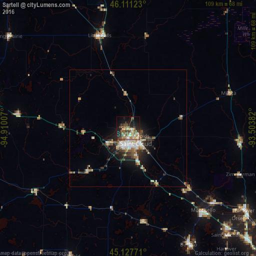
Analysis of Sartell night lights 2016
Square area 10x10 km:
 4.09%
4.09%90-99
7.12%80-89
3.94%70-79
3.48%60-69
7.27%50-59
10.45%40-49
10.45%30-39
4.09%20-29
11.21%10-19
20%0-9
17.88%Square area 50x50 km:
1.04%90-99
1.25%80-89
0.61%70-79
0.89%60-69
0.69%50-59
1.17%40-49
1.2%30-39
1.19%20-29
2.07%10-19
3.82%0-9
86.06%Clear (daylight) street map image can be seen on geolist.org.
Map coordinates:
46° 6' 40.4" North, 94° 54' 36.3" West
45° 37' 17.9" North, 94° 12' 25" West
45° 7' 39.8" North, 93° 30' 13.8" West
Some cities around Sartell sort by population:
• Saint Cloud
7.6 km =4.7 mi,  152°
152°
• Sauk Rapids
4.6 km =2.9 mi,  136°
136°
• Monticello
47.7 km =29.6 mi, 137°
• Big Lake
48.2 km =30 mi,  131°
131°
• Little Falls
41.2 km =25.6 mi,  342°
342°
• Waite Park
7.3 km =4.5 mi,  190°
190°
• Saint Joseph
10.7 km =6.6 mi,  233°
233°
• Zimmerman
52 km =32.3 mi,  112°
112°
5046001 (p: 16,788)
Sources (retrieved 2019-11-25):
» Earth at Night: Flat Maps 2012, 2016