Saint Joseph night lights from space
Night Light of Saint Joseph (Minnesota) from space (United States) Src. Average luminocity for 10x10km area is 17.8273% and for 50x50km: 7.0449%.
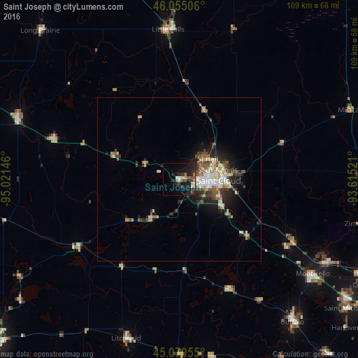
Analysis of Saint Joseph night lights 2016
Square area 10x10 km:
 1.06%
1.06%90-99
1.36%80-89
1.82%70-79
2.88%60-69
2.12%50-59
1.97%40-49
2.88%30-39
4.24%20-29
7.88%10-19
20.61%0-9
53.18%Square area 50x50 km:
1.03%90-99
1.26%80-89
0.61%70-79
0.9%60-69
0.7%50-59
1.18%40-49
1.16%30-39
1.21%20-29
2.02%10-19
3.79%0-9
86.13%Clear (daylight) street map image can be seen on geolist.org.
Map coordinates:
46° 3' 18.2" North, 95° 1' 17.3" West
45° 33' 53.9" North, 94° 19' 6" West
45° 4' 14" North, 93° 36' 54.8" West
Some cities around Saint Joseph sort by population:
• Sartell
10.7 km =6.6 mi,  53°
53°
• Buffalo
55.8 km =34.7 mi,  141°
141°
• Sauk Rapids
12.2 km =7.6 mi,  75°
75°
• Monticello
50 km =31.1 mi,  125°
125°
• Big Lake
51.6 km =32.1 mi,  120°
120°
• Little Falls
45.9 km =28.5 mi,  355°
355°
• Waite Park
7.4 km =4.6 mi,  96°
96°
• Litchfield
51.4 km =31.9 mi,  198°
198°
5044896 (p: 6,534)
Sources (retrieved 2019-11-25):
» Earth at Night: Flat Maps 2012, 2016