Carriere night lights from space
Night Light of Carriere (Mississippi) from space (United States) Src. Average luminocity for 10x10km area is 22.9563% and for 50x50km: 7.7997%.
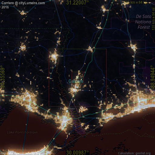
Analysis of Carriere night lights 2016
Square area 10x10 km:
 0%
0%90-99
0%80-89
3.15%70-79
4.02%60-69
3.32%50-59
4.55%40-49
4.72%30-39
8.92%20-29
7.52%10-19
27.8%0-9
36.01%Square area 50x50 km:
0.4%90-99
0.44%80-89
1.15%70-79
1.07%60-69
1.24%50-59
0.82%40-49
1.9%30-39
2.2%20-29
1.89%10-19
6.79%0-9
82.1%Clear (daylight) street map image can be seen on geolist.org.
Map coordinates:
31° 13' 12.3" North, 90° 21' 20.5" West
30° 37' 0.7" North, 89° 39' 9.2" West
30° 0' 35.5" North, 88° 56' 58" West
Some cities around Carriere sort by population:
• Slidell
39.9 km =24.8 mi,  197°
197°
• Bogalusa
27 km =16.8 mi,  315°
315°
• Picayune
10.4 km =6.5 mi,  193°
193°
• Covington
45.7 km =28.4 mi,  249°
249°
• Lacombe
43.7 km =27.2 mi,  219°
219°
• Diamondhead
37.1 km =23.1 mi,  131°
131°
• Eden Isle
45.4 km =28.2 mi, 197°
• Waveland
45.3 km =28.1 mi,  144°
144°
4420719 (p: 13,198)
Sources (retrieved 2019-11-25):
» Earth at Night: Flat Maps 2012, 2016