Boaz night lights from space
Night Light of Boaz (Alabama) from space (United States) Src. Average luminocity for 10x10km area is 42.6722% and for 50x50km: 13.2705%.
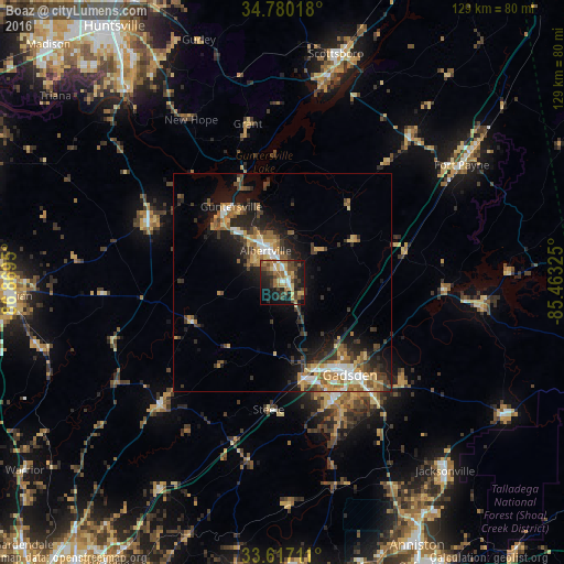
Analysis of Boaz night lights 2016
Square area 10x10 km:
 3.3%
3.3%90-99
4.4%80-89
8.42%70-79
3.85%60-69
11.72%50-59
4.76%40-49
12.82%30-39
5.31%20-29
15.38%10-19
24.36%0-9
5.68%Square area 50x50 km:
1.37%90-99
1.39%80-89
1.84%70-79
1.8%60-69
2.7%50-59
1.78%40-49
2.24%30-39
2.85%20-29
3.84%10-19
8.25%0-9
71.93%Clear (daylight) street map image can be seen on geolist.org.
Map coordinates:
34° 46' 48.6" North, 86° 52' 10.2" West
34° 12' 2.3" North, 86° 9' 58.9" West
33° 37' 1.6" North, 85° 27' 47.7" West
Some cities around Boaz sort by population:
• Gadsden
25.4 km =15.8 mi,  144°
144°
• Albertville
8.4 km =5.2 mi,  332°
332°
• Rainbow City
29.6 km =18.4 mi,  157°
157°
• Southside
33.4 km =20.8 mi, 156°
• Guntersville
21.1 km =13.1 mi, 326°
• Arab
33 km =20.5 mi,  293°
293°
• Attalla
21.1 km =13.1 mi, 160°
• Glencoe
34.6 km =21.5 mi, 141°
4051059 (p: 9,688)
Sources (retrieved 2019-11-25):
» Earth at Night: Flat Maps 2012, 2016