Rainbow City night lights from space
Night Light of Rainbow City (Alabama) from space (United States) Src. Average luminocity for 10x10km area is 60.1503% and for 50x50km: 13.8263%.
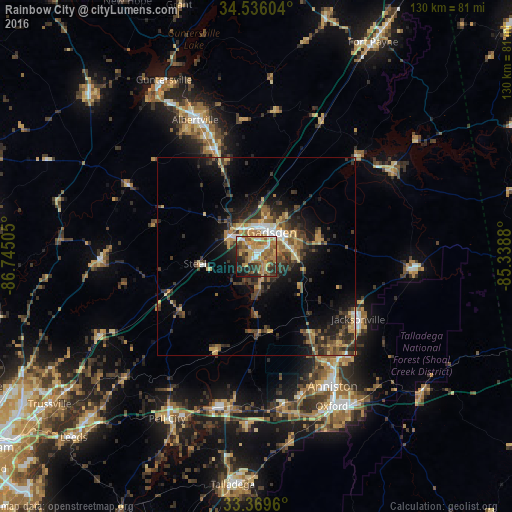
Analysis of Rainbow City night lights 2016
Square area 10x10 km:
 7.17%
7.17%90-99
7.17%80-89
9.79%70-79
14.34%60-69
16.61%50-59
12.06%40-49
7.34%30-39
9.09%20-29
10.66%10-19
5.42%0-9
0.35%Square area 50x50 km:
0.99%90-99
1.01%80-89
1.96%70-79
2.18%60-69
2.51%50-59
2.04%40-49
2.79%30-39
4.28%20-29
4.07%10-19
7.39%0-9
70.77%Clear (daylight) street map image can be seen on geolist.org.
Map coordinates:
34° 32' 9.7" North, 86° 44' 42.2" West
33° 57' 17.4" North, 86° 2' 30.9" West
33° 22' 10.6" North, 85° 20' 19.7" West
Some cities around Rainbow City sort by population:
• Gadsden
7.4 km =4.6 mi,  26°
26°
• Albertville
38 km =23.6 mi,  336°
336°
• Jacksonville
30.3 km =18.8 mi,  121°
121°
• Saks
34.1 km =21.2 mi,  146°
146°
• Boaz
29.6 km =18.4 mi, 337°
• Southside
3.8 km =2.4 mi, 151°
• Attalla
8.6 km =5.3 mi,  329°
329°
• Glencoe
10.1 km =6.3 mi,  88°
88°
4085336 (p: 9,580)
Sources (retrieved 2019-11-25):
» Earth at Night: Flat Maps 2012, 2016