Attalla night lights from space
Night Light of Attalla (Alabama) from space (United States) Src. Average luminocity for 10x10km area is 48.201% and for 50x50km: 13.3259%.
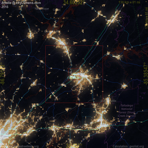
Analysis of Attalla night lights 2016
Square area 10x10 km:
 6.64%
6.64%90-99
6.64%80-89
6.47%70-79
10.66%60-69
10.14%50-59
5.24%40-49
6.64%30-39
8.57%20-29
13.81%10-19
20.28%0-9
4.9%Square area 50x50 km:
1.1%90-99
1.14%80-89
1.84%70-79
1.96%60-69
2.71%50-59
1.78%40-49
2.51%30-39
3.55%20-29
3.57%10-19
7.73%0-9
72.09%Clear (daylight) street map image can be seen on geolist.org.
Map coordinates:
34° 36' 9.1" North, 86° 47' 30.2" West
34° 1' 18.3" North, 86° 5' 18.9" West
33° 26' 13.2" North, 85° 23' 7.7" West
Some cities around Attalla sort by population:
• Gadsden
7.6 km =4.7 mi,  96°
96°
• Albertville
29.5 km =18.3 mi,  337°
337°
• Jacksonville
38 km =23.6 mi,  127°
127°
• Boaz
21.1 km =13.1 mi, 340°
• Rainbow City
8.6 km =5.3 mi,  149°
149°
• Southside
12.4 km =7.7 mi, 150°
• Oneonta
36.4 km =22.6 mi,  256°
256°
• Glencoe
16.1 km =10 mi,  116°
116°
4830768 (p: 5,899)
Sources (retrieved 2019-11-25):
» Earth at Night: Flat Maps 2012, 2016