Bluefield night lights from space
Night Light of Bluefield (Virginia) from space (United States) Src. Average luminocity for 10x10km area is 41.0102% and for 50x50km: 7.6696%.
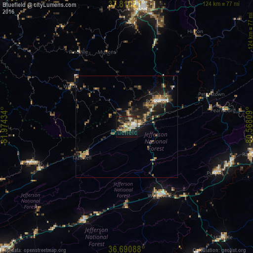
Analysis of Bluefield night lights 2016
Square area 10x10 km:
 5.95%
5.95%90-99
5.61%80-89
9.52%70-79
2.55%60-69
6.8%50-59
4.93%40-49
5.44%30-39
7.14%20-29
13.78%10-19
28.74%0-9
9.52%Square area 50x50 km:
0.46%90-99
0.59%80-89
0.92%70-79
0.91%60-69
1.43%50-59
1.31%40-49
1.19%30-39
1.94%20-29
2.37%10-19
6.31%0-9
82.56%Clear (daylight) street map image can be seen on geolist.org.
Map coordinates:
37° 48' 36.8" North, 81° 58' 27.6" West
37° 15' 9.4" North, 81° 16' 16.4" West
36° 41' 27.2" North, 80° 34' 5.1" West
Some cities around Bluefield sort by population:
• Radford
63 km =39.1 mi,  102°
102°
• Beckley
58.9 km =36.6 mi,  7°
7°
• Pulaski
49.1 km =30.5 mi,  117°
117°
• Wytheville
37.6 km =23.4 mi,  153°
153°
• Galax
72.6 km =45.1 mi, 154°
• Princeton
19.5 km =12.1 mi,  49°
49°
• Marion
51.2 km =31.8 mi,  204°
204°
• Richlands
49.6 km =30.8 mi,  249°
249°
4748125 (p: 5,279)
Sources (retrieved 2019-11-25):
» Earth at Night: Flat Maps 2012, 2016