Princeton night lights from space
Night Light of Princeton (West Virginia) from space (United States) Src. Average luminocity for 10x10km area is 39.9513% and for 50x50km: 6.7676%.
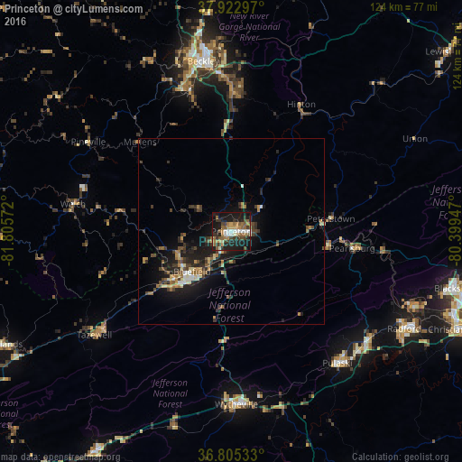
Analysis of Princeton night lights 2016
Square area 10x10 km:
 4.06%
4.06%90-99
5.68%80-89
1.62%70-79
5.52%60-69
9.74%50-59
9.74%40-49
3.57%30-39
10.39%20-29
12.18%10-19
33.93%0-9
3.57%Square area 50x50 km:
0.46%90-99
0.59%80-89
0.8%70-79
0.75%60-69
1.14%50-59
1.08%40-49
1.08%30-39
1.71%20-29
2.3%10-19
6.25%0-9
83.86%Clear (daylight) street map image can be seen on geolist.org.
Map coordinates:
37° 55' 22.7" North, 81° 48' 20.6" West
37° 21' 58.4" North, 81° 6' 9.3" West
36° 48' 19.2" North, 80° 23' 58.1" West
Some cities around Princeton sort by population:
• Blacksburg
62.8 km =39 mi,  104°
104°
• Christiansburg
66.8 km =41.5 mi,  113°
113°
• Radford
53.4 km =33.2 mi,  119°
119°
• Beckley
46.4 km =28.8 mi,  350°
350°
• Bluefield
15.1 km =9.4 mi,  224°
224°
• Pulaski
45.5 km =28.3 mi,  141°
141°
• Wytheville
46.5 km =28.9 mi,  178°
178°
• Bluefield
19.5 km =12.1 mi,  229°
229°
4819079 (p: 6,035)
Sources (retrieved 2019-11-25):
» Earth at Night: Flat Maps 2012, 2016