Richlands night lights from space
Night Light of Richlands (Virginia) from space (United States) Src. Average luminocity for 10x10km area is 23.9422% and for 50x50km: 2.7963%.
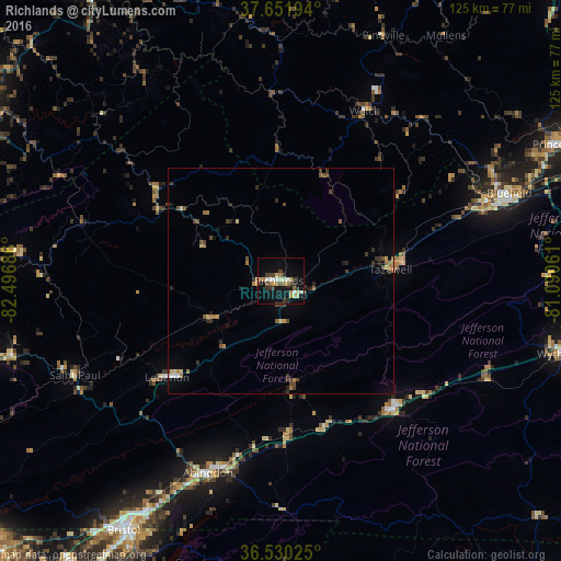
Analysis of Richlands night lights 2016
Square area 10x10 km:
 1.53%
1.53%90-99
4.25%80-89
3.06%70-79
2.55%60-69
3.91%50-59
3.23%40-49
2.72%30-39
6.63%20-29
1.87%10-19
22.11%0-9
48.13%Square area 50x50 km:
0.11%90-99
0.25%80-89
0.31%70-79
0.26%60-69
0.55%50-59
0.5%40-49
0.63%30-39
0.72%20-29
0.46%10-19
1.18%0-9
95.03%Clear (daylight) street map image can be seen on geolist.org.
Map coordinates:
37° 39' 7" North, 82° 29' 48.7" West
37° 5' 35.4" North, 81° 47' 37.4" West
36° 31' 48.9" North, 81° 5' 26.2" West
Some cities around Richlands sort by population:
• Bristol
65.6 km =40.8 mi,  212°
212°
• Bristol
65.4 km =40.6 mi, 212°
• Bluefield
54.3 km =33.7 mi,  68°
68°
• Abingdon
45.6 km =28.3 mi,  200°
200°
• Wytheville
65 km =40.4 mi,  104°
104°
• Princeton
68.3 km =42.4 mi,  63°
63°
• Marion
37.9 km =23.5 mi,  139°
139°
• Bluefield
49.6 km =30.8 mi, 69°
4781711 (p: 5,504)
Sources (retrieved 2019-11-25):
» Earth at Night: Flat Maps 2012, 2016