Pulaski night lights from space
Night Light of Pulaski (Virginia) from space (United States) Src. Average luminocity for 10x10km area is 22.2279% and for 50x50km: 5.1628%.
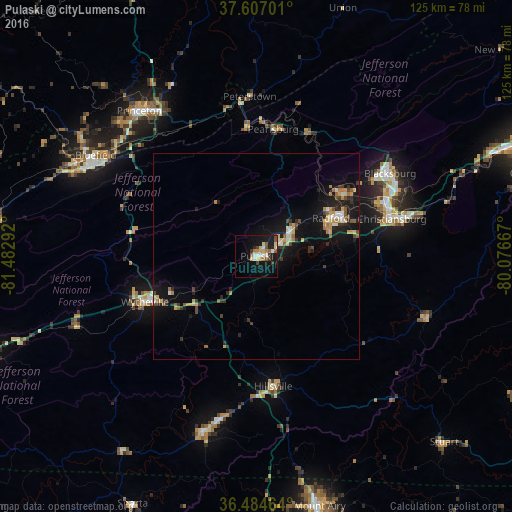
Analysis of Pulaski night lights 2016
Square area 10x10 km:
 2.55%
2.55%90-99
3.4%80-89
4.08%70-79
2.55%60-69
1.87%50-59
4.25%40-49
1.87%30-39
2.89%20-29
1.87%10-19
22.45%0-9
52.21%Square area 50x50 km:
0.33%90-99
0.57%80-89
0.87%70-79
0.66%60-69
0.54%50-59
0.76%40-49
0.55%30-39
0.93%20-29
1.07%10-19
5.67%0-9
88.06%Clear (daylight) street map image can be seen on geolist.org.
Map coordinates:
37° 36' 25.2" North, 81° 28' 58.5" West
37° 2' 52.4" North, 80° 46' 47.2" West
36° 29' 4.7" North, 80° 4' 36" West
Some cities around Pulaski sort by population:
• Blacksburg
38.2 km =23.7 mi,  58°
58°
• Christiansburg
34.1 km =21.2 mi,  74°
74°
• Radford
20.3 km =12.6 mi, 62°
• Bluefield
46.3 km =28.8 mi,  302°
302°
• Wytheville
29.3 km =18.2 mi,  247°
247°
• Galax
44.9 km =27.9 mi,  196°
196°
• Princeton
45.5 km =28.3 mi,  321°
321°
• Bluefield
49.1 km =30.5 mi, 297°
4780577 (p: 8,890)
Sources (retrieved 2019-11-25):
» Earth at Night: Flat Maps 2012, 2016