Wytheville night lights from space
Night Light of Wytheville (Virginia) from space (United States) Src. Average luminocity for 10x10km area is 26.5471% and for 50x50km: 2.5243%.
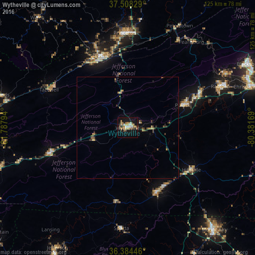
Analysis of Wytheville night lights 2016
Square area 10x10 km:
 3.25%
3.25%90-99
3.08%80-89
4.06%70-79
4.22%60-69
4.06%50-59
3.41%40-49
3.41%30-39
2.44%20-29
2.11%10-19
32.95%0-9
37.01%Square area 50x50 km:
0.15%90-99
0.14%80-89
0.33%70-79
0.41%60-69
0.42%50-59
0.35%40-49
0.33%30-39
0.57%20-29
0.49%10-19
1.72%0-9
95.1%Clear (daylight) street map image can be seen on geolist.org.
Map coordinates:
37° 30' 29.8" North, 81° 47' 16.6" West
36° 56' 54.4" North, 81° 5' 5.3" West
36° 23' 4.1" North, 80° 22' 54.1" West
Some cities around Wytheville sort by population:
• Christiansburg
63.3 km =39.3 mi,  71°
71°
• Radford
49.5 km =30.8 mi, 65°
• Bluefield
37.8 km =23.5 mi,  341°
341°
• Pulaski
29.3 km =18.2 mi, 67°
• Galax
35 km =21.7 mi,  155°
155°
• Princeton
46.5 km =28.9 mi,  358°
358°
• Marion
40.3 km =25 mi,  251°
251°
• Bluefield
37.6 km =23.4 mi,  333°
333°
4794837 (p: 8,115)
Sources (retrieved 2019-11-25):
» Earth at Night: Flat Maps 2012, 2016