Nanticoke night lights from space
Night Light of Nanticoke (Pennsylvania) from space (United States) Src. Average luminocity for 10x10km area is 24.4724% and for 50x50km: 13.2639%.
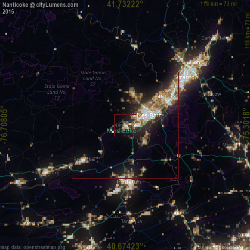
Analysis of Nanticoke night lights 2016
Square area 10x10 km:
 1.62%
1.62%90-99
2.27%80-89
3.41%70-79
2.76%60-69
4.87%50-59
3.08%40-49
4.06%30-39
5.84%20-29
9.74%10-19
22.56%0-9
39.77%Square area 50x50 km:
1.54%90-99
1.86%80-89
1.29%70-79
2.01%60-69
1.96%50-59
2.16%40-49
2.27%30-39
2.37%20-29
4.65%10-19
7.52%0-9
72.38%Clear (daylight) street map image can be seen on geolist.org.
Map coordinates:
41° 43' 56" North, 76° 42' 29" West
41° 12' 19.3" North, 76° 0' 17.7" West
40° 40' 27.2" North, 75° 18' 6.5" West
Some cities around Nanticoke sort by population:
• Wilkes-Barre
11.3 km =7 mi,  66°
66°
• Back Mountain
14.5 km =9 mi,  2°
2°
• Kingston
11 km =6.8 mi,  55°
55°
• Mountain Top
11.4 km =7.1 mi,  110°
110°
• Berwick
25.4 km =15.8 mi,  228°
228°
• Pittston
22.5 km =14 mi,  53°
53°
• Plymouth
6.4 km =4 mi, 52°
• Exeter
20.1 km =12.5 mi, 50°
5202855 (p: 10,258)
Sources (retrieved 2019-11-25):
» Earth at Night: Flat Maps 2012, 2016