Bellwood night lights from space
Night Light of Bellwood (Virginia) from space (United States) Src. Average luminocity for 10x10km area is 72.4821% and for 50x50km: 44.5651%.
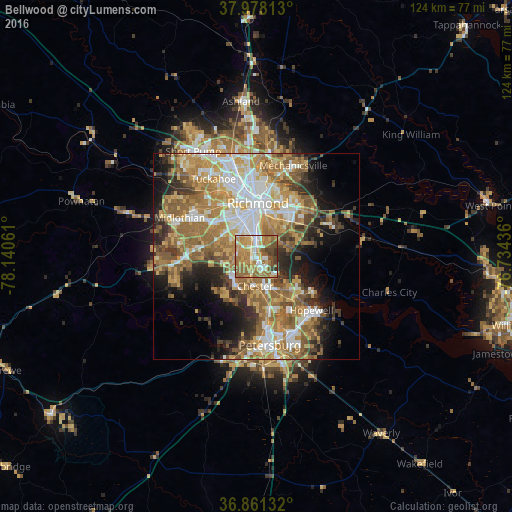
Analysis of Bellwood night lights 2016
Square area 10x10 km:
 12.5%
12.5%90-99
11.53%80-89
8.93%70-79
20.29%60-69
24.68%50-59
11.04%40-49
7.14%30-39
3.9%20-29
0%10-19
0%0-9
0%Square area 50x50 km:
7.79%90-99
7.48%80-89
5.86%70-79
8.74%60-69
10.22%50-59
8.78%40-49
4.25%30-39
4.9%20-29
6.03%10-19
8.54%0-9
27.42%Clear (daylight) street map image can be seen on geolist.org.
Map coordinates:
37° 58' 41.3" North, 78° 8' 26.2" West
37° 25' 18.5" North, 77° 26' 14.9" West
36° 51' 40.8" North, 76° 44' 3.7" West
Some cities around Bellwood sort by population:
• Richmond
14.8 km =9.2 mi,  352°
352°
• Chester
7.2 km =4.5 mi,  182°
182°
• Meadowbrook
4.4 km =2.7 mi,  313°
313°
• Bon Air
15.6 km =9.7 mi,  317°
317°
• Montrose
12.2 km =7.6 mi,  25°
25°
• Sandston
15.6 km =9.7 mi,  43°
43°
• Fort Lee
12.2 km =7.6 mi,  47°
47°
• Bensley
2.8 km =1.7 mi, 349°
4746526 (p: 6,352)
Sources (retrieved 2019-11-25):
» Earth at Night: Flat Maps 2012, 2016