Bon Air night lights from space
Night Light of Bon Air (Virginia) from space (United States) Src. Average luminocity for 10x10km area is 78.7597% and for 50x50km: 43.7437%.
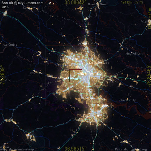
Analysis of Bon Air night lights 2016
Square area 10x10 km:
 16.23%
90-99
18.34%80-89
8.77%70-79
17.05%60-69
34.42%50-59
3.73%40-49
1.14%30-39
0.32%20-29
0%10-19
0%0-9
0%Square area 50x50 km:
7.34%90-99
6.94%80-89
5.98%70-79
8.52%60-69
10.38%50-59
8.76%40-49
4.27%30-39
4.66%20-29
6.24%10-19
8.97%0-9
27.94%Clear (daylight) street map image can be seen on geolist.org.
Map coordinates:
38° 4' 49.5" North, 78° 15' 39.2" West
37° 31' 29.5" North, 77° 33' 28" West
36° 57' 54.5" North, 76° 51' 16.7" West
Some cities around Bon Air sort by population:
• Richmond
9.2 km =5.7 mi,  69°
69°
• Tuckahoe
7.3 km =4.5 mi,  0°
0°
• Meadowbrook
11.3 km =7 mi,  138°
138°
• Laurel
13.8 km =8.6 mi,  18°
18°
• Brandermill
13.1 km =8.1 mi,  218°
218°
• Lakeside
11.6 km =7.2 mi,  37°
37°
• Dumbarton
10.5 km =6.5 mi,  33°
33°
• Bensley
13.3 km =8.3 mi,  130°
130°
4748305 (p: 16,366)
Sources (retrieved 2019-11-25):
» Earth at Night: Flat Maps 2012, 2016