Lake Mills night lights from space
Night Light of Lake Mills (Wisconsin) from space (United States) Src. Average luminocity for 10x10km area is 9.0143% and for 50x50km: 6.3571%.
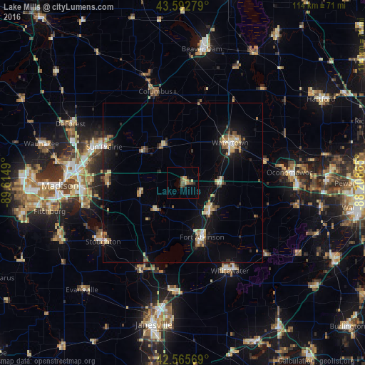
Analysis of Lake Mills night lights 2016
Square area 10x10 km:
 0%
0%90-99
0%80-89
1.59%70-79
2.06%60-69
1.43%50-59
1.9%40-49
3.17%30-39
1.27%20-29
0.95%10-19
1.27%0-9
86.35%Square area 50x50 km:
0.38%90-99
0.58%80-89
1.21%70-79
0.73%60-69
0.91%50-59
0.89%40-49
0.8%30-39
0.77%20-29
1.03%10-19
5.15%0-9
87.57%Clear (daylight) street map image can be seen on geolist.org.
Map coordinates:
43° 35' 34" North, 89° 36' 53.6" West
43° 4' 53" North, 88° 54' 42.4" West
42° 33' 56.5" North, 88° 12' 31.1" West
Some cities around Lake Mills sort by population:
• Sun Prairie
27 km =16.8 mi,  294°
294°
• Watertown
19.5 km =12.1 mi,  49°
49°
• Whitewater
31.2 km =19.4 mi,  152°
152°
• Stoughton
30.9 km =19.2 mi,  233°
233°
• Fort Atkinson
18 km =11.2 mi,  160°
160°
• Jefferson
12 km =7.5 mi,  134°
134°
• Cottage Grove
23.4 km =14.5 mi,  268°
268°
• Edgerton
30.2 km =18.8 mi,  204°
204°
5259218 (p: 5,798)
Sources (retrieved 2019-11-25):
» Earth at Night: Flat Maps 2012, 2016