Bayport night lights from space
Night Light of Bayport (New York) from space (United States) Src. Average luminocity for 10x10km area is 50.3604% and for 50x50km: 33.6859%.
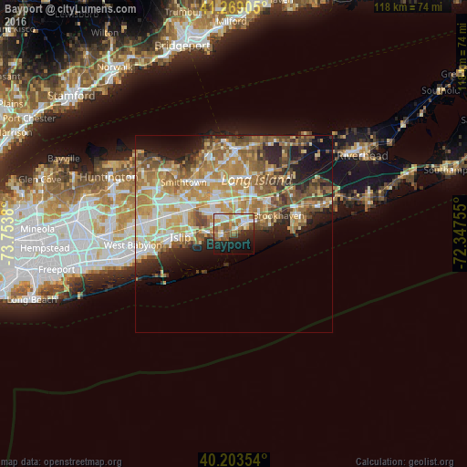
Analysis of Bayport night lights 2016
Square area 10x10 km:
 10.06%
90-99
11.2%80-89
4.87%70-79
7.47%60-69
9.74%50-59
11.04%40-49
1.79%30-39
1.46%20-29
12.82%10-19
19.81%0-9
9.74%Square area 50x50 km:
4.71%90-99
6.09%80-89
5.25%70-79
7.15%60-69
6.81%50-59
5.82%40-49
4.21%30-39
3.01%20-29
5.49%10-19
7.94%0-9
43.52%Clear (daylight) street map image can be seen on geolist.org.
Map coordinates:
41° 16' 8.6" North, 73° 45' 13.7" West
40° 44' 18.3" North, 73° 3' 2.4" West
40° 12' 12.7" North, 72° 20' 51.2" West
Some cities around Bayport sort by population:
• Holbrook
8.5 km =5.3 mi,  344°
344°
• East Patchogue
5.6 km =3.5 mi,  55°
55°
• Sayville
2.7 km =1.7 mi,  263°
263°
• Patchogue
4.3 km =2.7 mi,  44°
44°
• Bohemia
6.4 km =4 mi,  302°
302°
• Oakdale
7.4 km =4.6 mi,  274°
274°
• North Patchogue
6.4 km =4 mi,  32°
32°
• West Sayville
4.1 km =2.5 mi,  253°
253°
5108191 (p: 8,896)
Sources (retrieved 2019-11-25):
» Earth at Night: Flat Maps 2012, 2016