Andover night lights from space
Night Light of Andover (Massachusetts) from space (United States) Src. Average luminocity for 10x10km area is 59.3318% and for 50x50km: 45.891%.
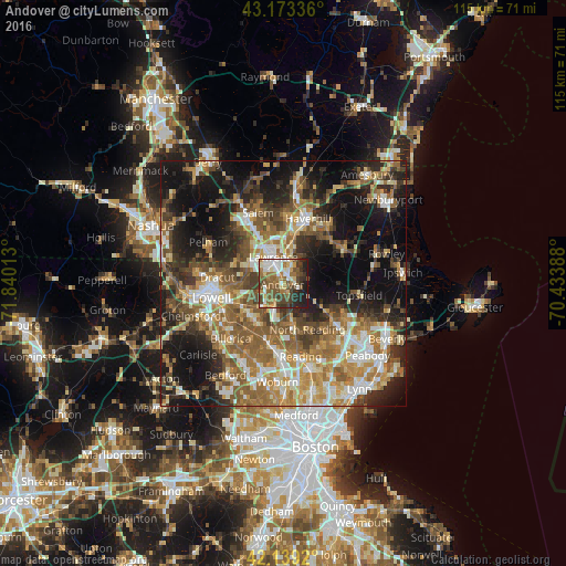
Analysis of Andover night lights 2016
Square area 10x10 km:
 8.64%
8.64%90-99
13.03%80-89
7.73%70-79
4.7%60-69
12.12%50-59
13.33%40-49
14.7%30-39
8.48%20-29
11.06%10-19
6.21%0-9
0%Square area 50x50 km:
5.83%90-99
7.83%80-89
5.69%70-79
6.89%60-69
9.24%50-59
9.86%40-49
6.87%30-39
6.59%20-29
10.58%10-19
18.69%0-9
11.92%Clear (daylight) street map image can be seen on geolist.org.
Map coordinates:
43° 10' 24.1" North, 71° 50' 24.5" West
42° 39' 30.3" North, 71° 8' 13.2" West
42° 8' 21.1" North, 70° 26' 2" West
Some cities around Andover sort by population:
• Lawrence
5.8 km =3.6 mi,  338°
338°
• Methuen
8.7 km =5.4 mi,  329°
329°
• Tewksbury
9.6 km =6 mi,  236°
236°
• Dracut
13.6 km =8.5 mi,  275°
275°
• North Andover
4.5 km =2.8 mi,  2°
2°
• Wilmington
12.8 km =8 mi,  193°
193°
• North Reading
10.4 km =6.5 mi,  152°
152°
• Middleton
12.1 km =7.5 mi,  125°
125°
4929055 (p: 8,762)
Sources (retrieved 2019-11-25):
» Earth at Night: Flat Maps 2012, 2016