Alabaster night lights from space
Night Light of Alabaster (Alabama) from space (United States) Src. Average luminocity for 10x10km area is 68.0402% and for 50x50km: 31.344%.

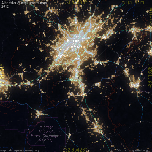
Analysis of Alabaster night lights 2016
Square area 10x10 km:
 8.04%
8.04%90-99
11.36%80-89
9.79%70-79
19.93%60-69
17.31%50-59
12.24%40-49
10.14%30-39
8.04%20-29
2.97%10-19
0.17%0-9
0%Square area 50x50 km:
3.95%90-99
4.96%80-89
5.19%70-79
6.25%60-69
6.45%50-59
3.87%40-49
4.14%30-39
4.65%20-29
5.75%10-19
10.9%0-9
43.88%Clear (daylight) street map image can be seen on geolist.org.
Map coordinates:
33° 49' 49.3" North, 87° 31' 10.2" West
33° 14' 39.4" North, 86° 48' 59" West
32° 39' 15.3" North, 86° 6' 47.7" West
Some cities around Alabaster sort by population:
• Hoover
17.9 km =11.1 mi,  1°
1°
• Bessemer
21.7 km =13.5 mi,  323°
323°
• Pelham
4.6 km =2.9 mi,  7°
7°
• Helena
6.3 km =3.9 mi,  336°
336°
• Calera
16.8 km =10.4 mi,  159°
159°
• Chelsea
20.3 km =12.6 mi,  58°
58°
• Meadowbrook
20.8 km =12.9 mi,  32°
32°
• Montevallo
16.6 km =10.3 mi,  195°
195°
4829762 (p: 32,707)
Sources (retrieved 2019-11-25):
» Earth at Night: Flat Maps 2012, 2016