Vodyane night lights from space
Night Light of Vodyane (Zaporizhia) from space (Ukraine) Src. Average luminocity for 10x10km area is 0.483% and for 50x50km: 3.667%.
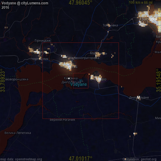
Analysis of Vodyane night lights 2016
Square area 10x10 km:
 0%
0%90-99
0%80-89
0%70-79
0%60-69
0%50-59
0%40-49
0%30-39
0%20-29
0%10-19
0.57%0-9
99.43%Square area 50x50 km:
0.45%90-99
0.56%80-89
0.38%70-79
0.54%60-69
0.42%50-59
0.41%40-49
0.47%30-39
0.32%20-29
0.68%10-19
3.21%0-9
92.56%Clear (daylight) street map image can be seen on geolist.org.
Map coordinates:
47° 57' 37.6" North, 33° 47' 21.2" East
47° 29' 14.9" North, 34° 29' 32.5" East
47° 0' 36.6" North, 35° 11' 43.7" East
Some cities around Vodyane sort by population:
• Nikopol
11.8 km =7.3 mi,  322°
322°
• Energodar
12.5 km =7.8 mi,  84°
84°
• Marhanets’
19.3 km =12 mi,  31°
31°
• Dniprorudne
38.3 km =23.8 mi,  107°
107°
• Verkhniy Rohachyk
28.8 km =17.9 mi,  203°
203°
• Chervonohryhorivka
15.5 km =9.6 mi,  13°
13°
• Balky
35.9 km =22.3 mi, 108°
• Vil’ne
29.3 km =18.2 mi,  55°
55°
689321 (p: 5,685)
Sources (retrieved 2019-11-25):
» Earth at Night: Flat Maps 2012, 2016