Rzhyshchiv night lights from space
Night Light of Rzhyshchiv (Kyiv) from space (Ukraine) Src. Average luminocity for 10x10km area is 0% and for 50x50km: 0.2694%.
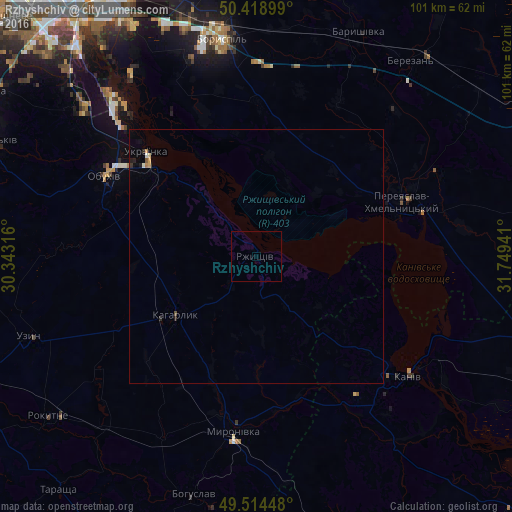
Analysis of Rzhyshchiv night lights 2016
Square area 10x10 km:
 0%
0%90-99
0%80-89
0%70-79
0%60-69
0%50-59
0%40-49
0%30-39
0%20-29
0%10-19
0%0-9
100%Square area 50x50 km:
0.02%90-99
0.03%80-89
0.02%70-79
0.06%60-69
0.04%50-59
0.02%40-49
0.02%30-39
0.02%20-29
0.09%10-19
0.07%0-9
99.61%Clear (daylight) street map image can be seen on geolist.org.
Map coordinates:
50° 25' 8.4" North, 30° 20' 35.4" East
49° 58' 7.9" North, 31° 2' 46.6" East
49° 30' 52.1" North, 31° 44' 57.9" East
Some cities around Rzhyshchiv sort by population:
• Boryspil’
43.2 km =26.8 mi,  351°
351°
• Pereiaslav-Khmelnytskyi
30.8 km =19.1 mi,  69°
69°
• Obukhiv
34.2 km =21.3 mi,  296°
296°
• Kaniv
38.2 km =23.7 mi,  129°
129°
• Ukrainka
28.9 km =18 mi,  312°
312°
• Kaharlyk
19.6 km =12.2 mi,  232°
232°
• Myronivka
34.6 km =21.5 mi,  187°
187°
• Hnidyn
46.6 km =29 mi,  329°
329°
694992 (p: 7,993)
Sources (retrieved 2019-11-25):
» Earth at Night: Flat Maps 2012, 2016