Mar'yinka night lights from space
Night Light of Mar'yinka (Donetsk) from space (Ukraine) Src. Average luminocity for 10x10km area is 0.1548% and for 50x50km: 6.1495%.
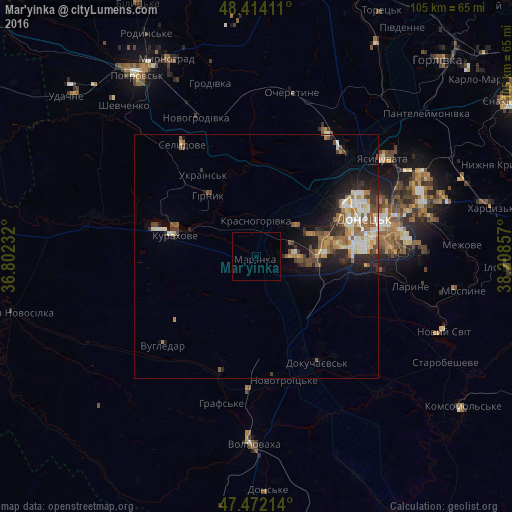
Analysis of Mar'yinka night lights 2016
Square area 10x10 km:
 0%
0%90-99
0%80-89
0%70-79
0%60-69
0%50-59
0%40-49
0%30-39
0%20-29
0%10-19
0%0-9
100%Square area 50x50 km:
0.64%90-99
1.26%80-89
0.65%70-79
0.7%60-69
0.95%50-59
1.28%40-49
0.76%30-39
0.82%20-29
1.69%10-19
3.38%0-9
87.87%Clear (daylight) street map image can be seen on geolist.org.
Map coordinates:
48° 24' 50.8" North, 36° 48' 8.4" East
47° 56' 43" North, 37° 30' 19.6" East
47° 28' 19.7" North, 38° 12' 30.9" East
Some cities around Mar'yinka sort by population:
• Donetsk
23.7 km =14.7 mi,  68°
68°
• Makiyivka
33.3 km =20.7 mi, 69°
• Yasynuvata
33.4 km =20.8 mi,  52°
52°
• Avdiyivka
27.9 km =17.3 mi,  39°
39°
• Selydove
27.1 km =16.8 mi,  325°
325°
• Dokuchayevs’k
25.3 km =15.7 mi,  149°
149°
• Volnovakha
38.3 km =23.8 mi,  180°
180°
• Kurakhovo
17.2 km =10.7 mi,  284°
284°
701845 (p: 9,900)
Sources (retrieved 2019-11-25):
» Earth at Night: Flat Maps 2012, 2016