Avdiyivka night lights from space
Night Light of Avdiyivka (Donetsk) from space (Ukraine) Src. Average luminocity for 10x10km area is 8.7619% and for 50x50km: 10.6513%.
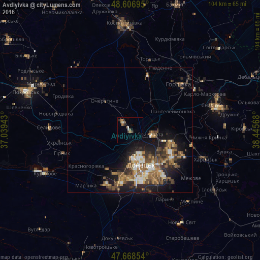
Analysis of Avdiyivka night lights 2016
Square area 10x10 km:
 0.3%
0.3%90-99
1.93%80-89
0.15%70-79
1.19%60-69
0.89%50-59
1.79%40-49
2.68%30-39
1.49%20-29
0.6%10-19
1.19%0-9
87.8%Square area 50x50 km:
0.9%90-99
1.77%80-89
0.97%70-79
1.42%60-69
1.71%50-59
2.67%40-49
2%30-39
1.6%20-29
3.17%10-19
6.29%0-9
77.5%Clear (daylight) street map image can be seen on geolist.org.
Map coordinates:
48° 36' 25" North, 37° 2' 21.9" East
48° 8' 23.6" North, 37° 44' 33.2" East
47° 40' 6.7" North, 38° 26' 44.4" East
Some cities around Avdiyivka sort by population:
• Donetsk
13.7 km =8.5 mi,  161°
161°
• Makiyivka
17 km =10.6 mi,  126°
126°
• Horlivka
31.7 km =19.7 mi,  46°
46°
• Khartsyz’k
32 km =19.9 mi,  109°
109°
• Toretsk
29.8 km =18.5 mi,  15°
15°
• Yasynuvata
8.7 km =5.4 mi,  97°
97°
• Nyzhnya Krynka
31.2 km =19.4 mi, 95°
• Mar'yinka
27.9 km =17.3 mi,  219°
219°
713122 (p: 35,826)
Sources (retrieved 2019-11-25):
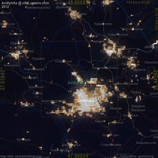
» Earth at Night: Flat Maps 2012, 2016