Mahdalynivka night lights from space
Night Light of Mahdalynivka (Dnipropetrovsk) from space (Ukraine) Src. Average luminocity for 10x10km area is 0.8594% and for 50x50km: 0.0907%.
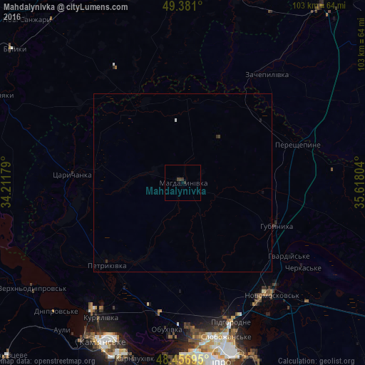
Analysis of Mahdalynivka night lights 2016
Square area 10x10 km:
 0%
0%90-99
0%80-89
0%70-79
0%60-69
0%50-59
0%40-49
0.71%30-39
1.42%20-29
0.14%10-19
0%0-9
97.73%Square area 50x50 km:
0.01%90-99
0.01%80-89
0%70-79
0%60-69
0%50-59
0%40-49
0.04%30-39
0.09%20-29
0.03%10-19
0.05%0-9
99.77%Clear (daylight) street map image can be seen on geolist.org.
Map coordinates:
49° 22' 51.6" North, 34° 12' 42.4" East
48° 55' 16" North, 34° 54' 53.7" East
48° 27' 25" North, 35° 37' 4.9" East
Some cities around Mahdalynivka sort by population:
• Dnipro
52.1 km =32.4 mi,  169°
169°
• Kamianske
51 km =31.7 mi,  206°
206°
• Novomoskovs’k
39.7 km =24.7 mi,  142°
142°
• Karlivka
61.6 km =38.3 mi,  14°
14°
• Pidhorodne
40.9 km =25.4 mi,  159°
159°
• Kobelyaky
58.2 km =36.2 mi,  295°
295°
• Tsarychanka
31.9 km =19.8 mi,  273°
273°
• Hubynykha
27.9 km =17.3 mi,  116°
116°
702356 (p: 6,567)
Sources (retrieved 2019-11-25):
» Earth at Night: Flat Maps 2012, 2016