Pidhorodne night lights from space
Night Light of Pidhorodne (Dnipropetrovsk) from space (Ukraine) Src. Average luminocity for 10x10km area is 22.5149% and for 50x50km: 11.3852%.
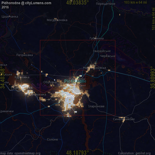
Analysis of Pidhorodne night lights 2016
Square area 10x10 km:
 2.08%
2.08%90-99
2.68%80-89
2.68%70-79
2.98%60-69
1.34%50-59
4.76%40-49
2.83%30-39
5.36%20-29
8.93%10-19
19.64%0-9
46.73%Square area 50x50 km:
2.13%90-99
2.23%80-89
1.08%70-79
1.41%60-69
1.37%50-59
1.52%40-49
1.87%30-39
2.05%20-29
2.9%10-19
4.51%0-9
78.93%Clear (daylight) street map image can be seen on geolist.org.
Map coordinates:
49° 2' 18.1" North, 34° 24' 13.2" East
48° 34' 31" North, 35° 6' 24.5" East
48° 6' 28.5" North, 35° 48' 35.7" East
Some cities around Pidhorodne sort by population:
• Dnipro
13.8 km =8.6 mi,  201°
201°
• Kamianske
37.8 km =23.5 mi,  259°
259°
• Pavlohrad
56.4 km =35 mi,  94°
94°
• Novomoskovs’k
12.4 km =7.7 mi,  55°
55°
• Synel’nykove
41.5 km =25.8 mi,  133°
133°
• Solone
44.4 km =27.6 mi, 202°
• Mahdalynivka
40.9 km =25.4 mi,  339°
339°
• Hubynykha
28.3 km =17.6 mi,  22°
22°
696943 (p: 17,103)
Sources (retrieved 2019-11-25):
» Earth at Night: Flat Maps 2012, 2016