Hlobyne night lights from space
Night Light of Hlobyne (Poltava) from space (Ukraine) Src. Average luminocity for 10x10km area is 3.6738% and for 50x50km: 0.9943%.
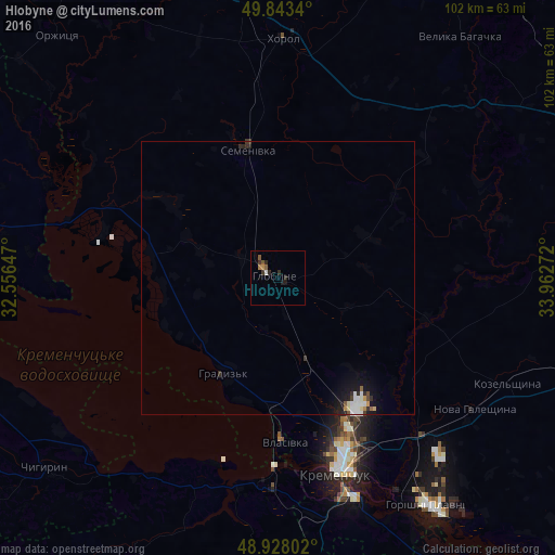
Analysis of Hlobyne night lights 2016
Square area 10x10 km:
 0.4%
0.4%90-99
0.13%80-89
0%70-79
0.53%60-69
0.53%50-59
1.6%40-49
0%30-39
1.2%20-29
2.01%10-19
1.07%0-9
92.51%Square area 50x50 km:
0.21%90-99
0.15%80-89
0.06%70-79
0.11%60-69
0.04%50-59
0.14%40-49
0.06%30-39
0.18%20-29
0.28%10-19
0.84%0-9
97.91%Clear (daylight) street map image can be seen on geolist.org.
Map coordinates:
49° 50' 36.2" North, 32° 33' 23.3" East
49° 23' 16.2" North, 33° 15' 34.5" East
48° 55' 40.9" North, 33° 57' 45.8" East
Some cities around Hlobyne sort by population:
• Kremenchuk
37.4 km =23.2 mi,  161°
161°
• Horishni Plavni
50.1 km =31.1 mi,  146°
146°
• Svitlovods’k
37.7 km =23.4 mi,  182°
182°
• Khorol
44 km =27.3 mi,  1°
1°
• Chyhyryn
55.4 km =34.4 mi,  232°
232°
• Hradyz’k
19.2 km =11.9 mi,  207°
207°
• Semenivka
23.2 km =14.4 mi,  345°
345°
• Velyka Bahachka
55.9 km =34.7 mi,  36°
36°
708753 (p: 12,544)
Sources (retrieved 2019-11-25):
» Earth at Night: Flat Maps 2012, 2016