Scarborough night lights from space
Night Light of Scarborough (Tobago) from space (Trinidad and Tobago) Src. Average luminocity for 10x10km area is 52.1407% and for 50x50km: 5.5853%.
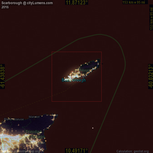
Analysis of Scarborough night lights 2016
Square area 10x10 km:
 6.71%
6.71%90-99
7.58%80-89
22.94%70-79
4.76%60-69
0.43%50-59
3.03%40-49
9.09%30-39
5.84%20-29
16.45%10-19
18.61%0-9
4.55%Square area 50x50 km:
0.59%90-99
0.67%80-89
1.84%70-79
0.41%60-69
0.24%50-59
0.31%40-49
0.84%30-39
0.65%20-29
1.44%10-19
4.49%0-9
88.52%Clear (daylight) street map image can be seen on geolist.org.
Map coordinates:
11° 52' 16.4" North, 61° 26' 18.2" West
11° 10' 56.2" North, 60° 44' 6.9" West
10° 29' 30.2" North, 60° 1' 55.7" West
Some cities around Scarborough sort by population:
• Port of Spain
103 km =64 mi,  236°
236°
• Arima
85.1 km =52.9 mi,  224°
224°
• Laventille
102.3 km =63.6 mi,  234°
234°
• Tunapuna
92.5 km =57.5 mi, 230°
• Sangre Grande
79 km =49.1 mi,  213°
213°
• Paradise
90.3 km =56.1 mi, 229°
• Arouca
89.9 km =55.9 mi, 226°
• Petit Valley
103.6 km =64.4 mi, 238°
3573703 (p: 17,000)
Sources (retrieved 2019-11-25):
» Earth at Night: Flat Maps 2012, 2016