Petit Valley night lights from space
Night Light of Petit Valley (Diego Martin) from space (Trinidad and Tobago) Src. Average luminocity for 10x10km area is 73.2893% and for 50x50km: 20.5694%.
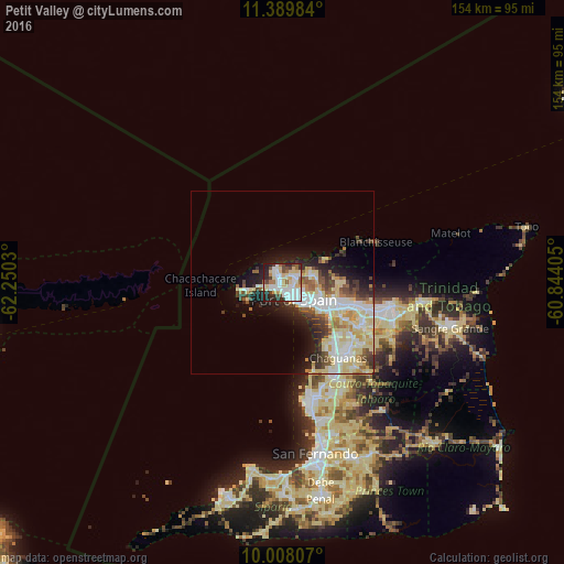
Analysis of Petit Valley night lights 2016
Square area 10x10 km:
 21.69%
90-99
21.69%80-89
15.91%70-79
3.93%60-69
4.75%50-59
3.93%40-49
8.06%30-39
4.96%20-29
13.02%10-19
2.07%0-9
0%Square area 50x50 km:
4.26%90-99
4.73%80-89
5.3%70-79
1.42%60-69
1.52%50-59
1.94%40-49
2.4%30-39
2.39%20-29
3.8%10-19
5.72%0-9
66.52%Clear (daylight) street map image can be seen on geolist.org.
Map coordinates:
11° 23' 23.4" North, 62° 15' 1.1" West
10° 41' 59.1" North, 61° 32' 49.8" West
10° 0' 29.1" North, 60° 50' 38.6" West
Some cities around Petit Valley sort by population:
• Chaguanas
24.9 km =15.5 mi,  144°
144°
• Port of Spain
4.8 km =3 mi, 139°
• Arima
29.8 km =18.5 mi,  103°
103°
• Laventille
7.7 km =4.8 mi, 136°
• Tunapuna
18.1 km =11.2 mi,  106°
106°
• Paradise
20.8 km =12.9 mi, 104°
• Arouca
24.5 km =15.2 mi, 108°
• Diego Martin
3.1 km =1.9 mi,  318°
318°
3573935 (p: 8,140)
Sources (retrieved 2019-11-25):
» Earth at Night: Flat Maps 2012, 2016