Yeşilyurt night lights from space
Night Light of Yeşilyurt (Tokat) from space (Turkey) Src. Average luminocity for 10x10km area is 10.5272% and for 50x50km: 6.5992%.
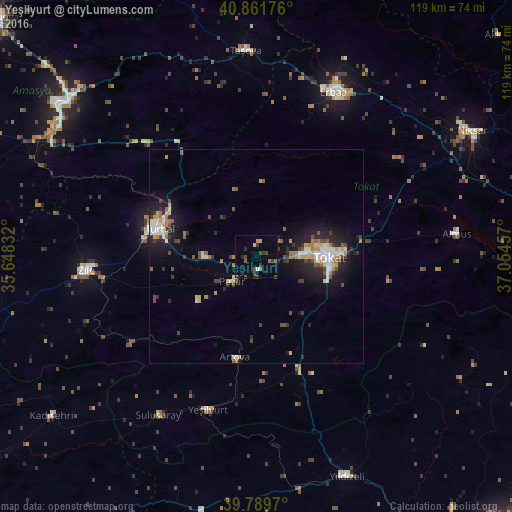
Analysis of Yeşilyurt night lights 2016
Square area 10x10 km:
100  0%
0%
90-99 0.68%
80-89 1.02%
70-79 1.7%
60-69 0.85%
50-59 1.87%
40-49 4.25%
30-39 2.55%
20-29 2.04%
10-19 1.02%
0-9 84.01%
0%90-99
0.68%80-89
1.02%70-79
1.7%60-69
0.85%50-59
1.87%40-49
4.25%30-39
2.55%20-29
2.04%10-19
1.02%0-9
84.01%Square area 50x50 km:
100 0.66%
90-99 1.24%
80-89 0.44%
70-79 0.95%
60-69 0.82%
50-59 0.72%
40-49 1.12%
30-39 0.95%
20-29 1.72%
10-19 4.85%
0-9 86.52%
0.66%90-99
1.24%80-89
0.44%70-79
0.95%60-69
0.82%50-59
0.72%40-49
1.12%30-39
0.95%20-29
1.72%10-19
4.85%0-9
86.52%Clear (daylight) street map image can be seen on geolist.org.
Map coordinates:
40° 51' 42.3" North, 35° 38' 54" East
40° 19' 40.3" North, 36° 21' 5.2" East
39° 47' 22.9" North, 37° 3' 16.5" East
Some cities around Yeşilyurt sort by population:
• Tokat
17.3 km =10.7 mi,  95°
95°
• Turhal
23.8 km =14.8 mi,  286°
286°
• Zile
39.5 km =24.5 mi,  265°
265°
• Erbaa
42.1 km =26.2 mi,  25°
25°
• Taşova
48.1 km =29.9 mi,  357°
357°
• Almus
47.2 km =29.3 mi,  83°
83°
• Artova
24 km =14.9 mi,  190°
190°
• Pazar
8.1 km =5 mi,  225°
225°
737529 (p: 6,860)
Sources (retrieved 2019-11-25):
» Earth at Night: Flat Maps 2012, 2016