Taşova night lights from space
Night Light of Taşova (Amasya) from space (Turkey) Src. Average luminocity for 10x10km area is 8.0227% and for 50x50km: 2.7278%.
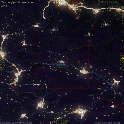
Analysis of Taşova night lights 2016
Square area 10x10 km:
100  0.49%
0.49%
90-99 2.11%
80-89 0.65%
70-79 0%
60-69 2.6%
50-59 1.62%
40-49 0.32%
30-39 0.65%
20-29 0%
10-19 0.65%
0-9 90.91%
0.49%90-99
2.11%80-89
0.65%70-79
0%60-69
2.6%50-59
1.62%40-49
0.32%30-39
0.65%20-29
0%10-19
0.65%0-9
90.91%Square area 50x50 km:
100 0.17%
90-99 0.37%
80-89 0.35%
70-79 0.22%
60-69 0.53%
50-59 0.49%
40-49 0.35%
30-39 0.48%
20-29 0.57%
10-19 2.02%
0-9 94.46%
0.17%90-99
0.37%80-89
0.35%70-79
0.22%60-69
0.53%50-59
0.49%40-49
0.35%30-39
0.48%20-29
0.57%10-19
2.02%0-9
94.46%Clear (daylight) street map image can be seen on geolist.org.
Map coordinates:
41° 17' 24.6" North, 35° 37' 9.8" East
40° 45' 35" North, 36° 19' 21" East
40° 13' 30" North, 37° 1' 32.3" East
Some cities around Taşova sort by population:
• Turhal
46.1 km =28.6 mi,  206°
206°
• Amasya
42.9 km =26.7 mi,  253°
253°
• Erbaa
23 km =14.3 mi,  116°
116°
• Tekkeköy
51.6 km =32.1 mi,  12°
12°
• Ladik
39.9 km =24.8 mi,  294°
294°
• Kavak
42.5 km =26.4 mi,  326°
326°
• Yeşilyurt
48.1 km =29.9 mi,  177°
177°
• Ayvacık
36.6 km =22.7 mi,  45°
45°
739015 (p: 19,253)
Sources (retrieved 2019-11-25):
» Earth at Night: Flat Maps 2012, 2016