Almus night lights from space
Night Light of Almus (Tokat) from space (Turkey) Src. Average luminocity for 10x10km area is 5.7024% and for 50x50km: 2.2505%.
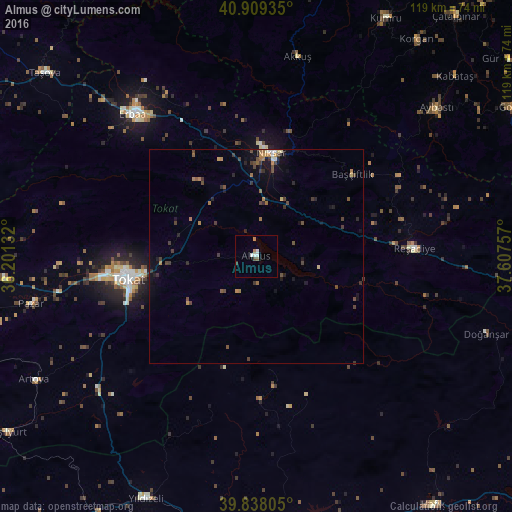
Analysis of Almus night lights 2016
Square area 10x10 km:
100  0.68%
0.68%
90-99 2.04%
80-89 0%
70-79 0.68%
60-69 0.68%
50-59 0.68%
40-49 0.68%
30-39 0.68%
20-29 0%
10-19 0%
0-9 93.88%
0.68%90-99
2.04%80-89
0%70-79
0.68%60-69
0.68%50-59
0.68%40-49
0.68%30-39
0.68%20-29
0%10-19
0%0-9
93.88%Square area 50x50 km:
100 0.09%
90-99 0.2%
80-89 0.13%
70-79 0.27%
60-69 0.49%
50-59 0.28%
40-49 0.7%
30-39 0.63%
20-29 0.43%
10-19 1.27%
0-9 95.51%
0.09%90-99
0.2%80-89
0.13%70-79
0.27%60-69
0.49%50-59
0.28%40-49
0.7%30-39
0.63%20-29
0.43%10-19
1.27%0-9
95.51%Clear (daylight) street map image can be seen on geolist.org.
Map coordinates:
40° 54' 33.7" North, 36° 12' 4.8" East
40° 22' 33" North, 36° 54' 16" East
39° 50' 17" North, 37° 36' 27.3" East
Some cities around Almus sort by population:
• Tokat
30.4 km =18.9 mi,  256°
256°
• Erbaa
43.3 km =26.9 mi,  318°
318°
• Niksar
24.3 km =15.1 mi,  9°
9°
• Akkuş
47.3 km =29.4 mi, 11°
• Başçiftlik
29.4 km =18.3 mi,  49°
49°
• Yeşilyurt
47.2 km =29.3 mi, 263°
• Artova
58.9 km =36.6 mi,  240°
240°
• Pazar
53.8 km =33.4 mi, 258°
752083 (p: 6,303)
Sources (retrieved 2019-11-25):
» Earth at Night: Flat Maps 2012, 2016