Yalıkavak night lights from space
Night Light of Yalıkavak (Muğla) from space (Turkey) Src. Average luminocity for 10x10km area is 49.0323% and for 50x50km: 11.113%.
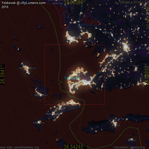
Analysis of Yalıkavak night lights 2016
Square area 10x10 km:
 0.85%
0.85%90-99
9.69%80-89
11.22%70-79
13.1%60-69
4.76%50-59
3.91%40-49
8.84%30-39
13.27%20-29
15.82%10-19
14.46%0-9
4.08%Square area 50x50 km:
0.63%90-99
2.05%80-89
1.68%70-79
2.41%60-69
0.91%50-59
0.73%40-49
1.34%30-39
2.23%20-29
3.55%10-19
9.08%0-9
75.39%Clear (daylight) street map image can be seen on geolist.org.
Map coordinates:
37° 39' 50.3" North, 26° 35' 38.8" East
37° 6' 19" North, 27° 17' 50" East
36° 32' 32.8" North, 28° 0' 1.3" East
Some cities around Yalıkavak sort by population:
• Milas
49.1 km =30.5 mi,  61°
61°
• Bodrum
13.9 km =8.6 mi,  122°
122°
• Didim
31.3 km =19.4 mi,  353°
353°
• Kos, GR
23.6 km =14.7 mi,  182°
182°
• Turgutreis
10.2 km =6.3 mi,  195°
195°
• Kálymnos, GR
32.7 km =20.3 mi,  238°
238°
• Datça
53.4 km =33.2 mi,  139°
139°
• Davutlar
69.9 km =43.4 mi,  359°
359°
297838 (p: 11,227)
Sources (retrieved 2019-11-25):
» Earth at Night: Flat Maps 2012, 2016