Milas night lights from space
Night Light of Milas (Muğla) from space (Turkey) Src. Average luminocity for 10x10km area is 38.8847% and for 50x50km: 8.9437%.
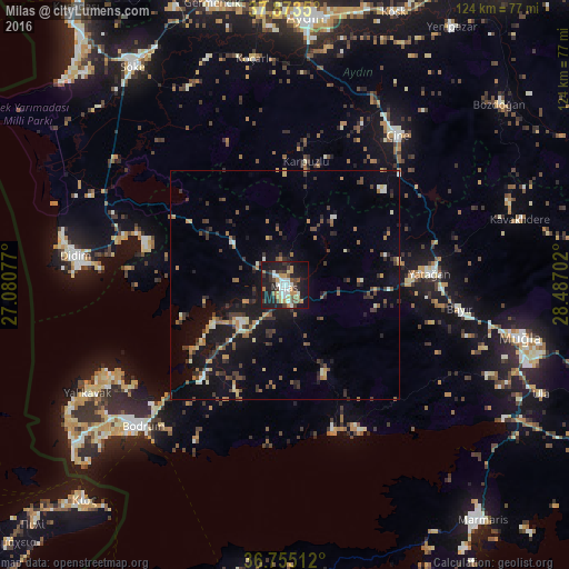

Analysis of Milas night lights 2016
Square area 10x10 km:
100  5.52%
5.52%
90-99 8.12%
80-89 2.11%
70-79 8.44%
60-69 3.08%
50-59 4.55%
40-49 4.22%
30-39 8.12%
20-29 10.39%
10-19 39.12%
0-9 6.33%
5.52%90-99
8.12%80-89
2.11%70-79
8.44%60-69
3.08%50-59
4.55%40-49
4.22%30-39
8.12%20-29
10.39%10-19
39.12%0-9
6.33%Square area 50x50 km:
100 0.33%
90-99 1.31%
80-89 0.64%
70-79 1.25%
60-69 1.14%
50-59 1.02%
40-49 1.53%
30-39 2.61%
20-29 1.93%
10-19 8.61%
0-9 79.63%
0.33%90-99
1.31%80-89
0.64%70-79
1.25%60-69
1.14%50-59
1.02%40-49
1.53%30-39
2.61%20-29
1.93%10-19
8.61%0-9
79.63%Clear (daylight) street map image can be seen on geolist.org.
Map coordinates:
37° 52' 24.6" North, 27° 4' 50.8" East
37° 18' 59" North, 27° 47' 2" East
36° 45' 18.4" North, 28° 29' 13.3" East
Some cities around Milas sort by population:
• Muğla
52.7 km =32.7 mi,  101°
101°
• Bodrum
44.1 km =27.4 mi,  225°
225°
• Didim
47.2 km =29.3 mi,  279°
279°
• Çine
40.9 km =25.4 mi,  36°
36°
• Yatağan
31.8 km =19.8 mi,  85°
85°
• Yalıkavak
49.1 km =30.5 mi,  241°
241°
• Acarlar
56.6 km =35.2 mi,  356°
356°
• Koçarlı
49.9 km =31 mi,  352°
352°
304355 (p: 43,193)
Sources (retrieved 2019-11-25):
» Earth at Night: Flat Maps 2012, 2016