Datça night lights from space
Night Light of Datça (Muğla) from space (Turkey) Src. Average luminocity for 10x10km area is 15.8864% and for 50x50km: 0.9509%.
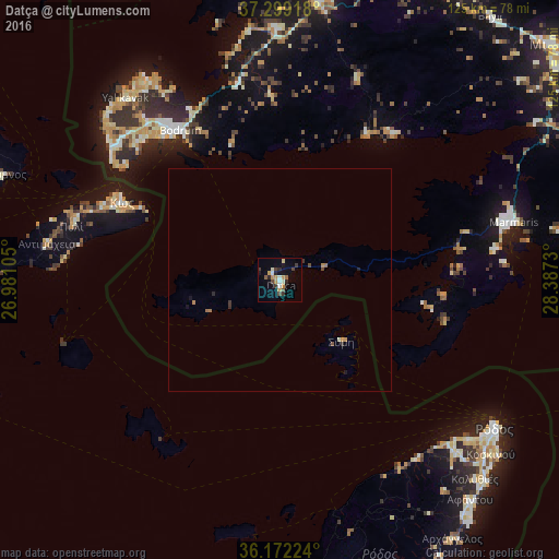
Analysis of Datça night lights 2016
Square area 10x10 km:
 1.22%
1.22%90-99
2.8%80-89
0.87%70-79
4.9%60-69
0.35%50-59
1.22%40-49
2.97%30-39
3.15%20-29
2.8%10-19
3.67%0-9
76.05%Square area 50x50 km:
0.05%90-99
0.14%80-89
0.03%70-79
0.25%60-69
0.13%50-59
0.08%40-49
0.19%30-39
0.22%20-29
0.18%10-19
0.22%0-9
98.51%Clear (daylight) street map image can be seen on geolist.org.
Map coordinates:
37° 17' 57" North, 26° 58' 51.8" East
36° 44' 16" North, 27° 41' 3" East
36° 10' 20.1" North, 28° 23' 14.3" East
Some cities around Datça sort by population:
• Ródos, GR
58.6 km =36.4 mi,  124°
124°
• Bodrum
40.4 km =25.1 mi,  325°
325°
• Marmaris
54.1 km =33.6 mi,  76°
76°
• Kos, GR
39.3 km =24.4 mi,  296°
296°
• Turgutreis
48.4 km =30.1 mi,  309°
309°
• Ialysós, GR
55.4 km =34.4 mi,  130°
130°
• Yalıkavak
53.4 km =33.2 mi,  319°
319°
• Faliraki, GR
63.9 km =39.7 mi, 133°
317543 (p: 10,121)
Sources (retrieved 2019-11-25):
» Earth at Night: Flat Maps 2012, 2016