Kos night lights from space
Night Light of Kos (South Aegean) from space (Greece) Src. Average luminocity for 10x10km area is 29.1396% and for 50x50km: 10.5223%.
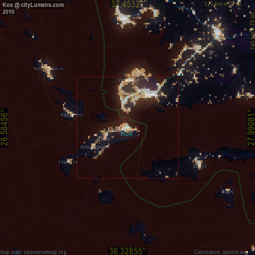
Analysis of Kos night lights 2016
Square area 10x10 km:
 2.27%
2.27%90-99
4.22%80-89
4.38%70-79
8.28%60-69
2.27%50-59
2.76%40-49
2.6%30-39
3.08%20-29
0.16%10-19
47.4%0-9
22.56%Square area 50x50 km:
0.59%90-99
1.93%80-89
1.53%70-79
2.13%60-69
0.84%50-59
0.81%40-49
1.37%30-39
2.42%20-29
3.54%10-19
8.5%0-9
76.33%Clear (daylight) street map image can be seen on geolist.org.
Map coordinates:
37° 27' 11.5" North, 26° 35' 4.4" East
36° 53' 34.6" North, 27° 17' 15.6" East
36° 19' 42.8" North, 27° 59' 26.9" East
Some cities around Kos sort by population:
• Milas, TR
64.4 km =40 mi,  43°
43°
• Bodrum, TR
20.5 km =12.7 mi, 37°
• Marmaris, TR
87.8 km =54.6 mi,  92°
92°
• Didim, TR
54.8 km =34.1 mi,  357°
357°
• Turgutreis, TR
13.9 km =8.6 mi,  352°
352°
• Kálymnos
27.7 km =17.2 mi,  283°
283°
• Yalıkavak, TR
23.6 km =14.7 mi,  2°
2°
• Datça, TR
39.3 km =24.4 mi,  116°
116°
259245 (p: 19,244)
Sources (retrieved 2019-11-25):
» Earth at Night: Flat Maps 2012, 2016