Kálymnos night lights from space
Night Light of Kálymnos (South Aegean) from space (Greece) Src. Average luminocity for 10x10km area is 8.9854% and for 50x50km: 4.7596%.
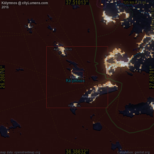
Analysis of Kálymnos night lights 2016
Square area 10x10 km:
 0%
0%90-99
1.46%80-89
1.3%70-79
3.08%60-69
0.97%50-59
0%40-49
1.95%30-39
1.79%20-29
1.62%10-19
0.49%0-9
87.34%Square area 50x50 km:
0.11%90-99
0.73%80-89
0.59%70-79
1.12%60-69
0.5%50-59
0.42%40-49
0.71%30-39
0.84%20-29
0.66%10-19
4.71%0-9
89.61%Clear (daylight) street map image can be seen on geolist.org.
Map coordinates:
37° 30' 36.5" North, 26° 16' 50.7" East
36° 57' 1.1" North, 26° 59' 2" East
36° 23' 10.8" North, 27° 41' 13.2" East
Some cities around Kálymnos sort by population:
• Milas, TR
81.8 km =50.8 mi,  60°
60°
• Bodrum, TR
40.7 km =25.3 mi,  76°
76°
• Didim, TR
54 km =33.6 mi,  26°
26°
• Kos
27.7 km =17.2 mi,  103°
103°
• Turgutreis, TR
26.2 km =16.3 mi,  73°
73°
• Yalıkavak, TR
32.7 km =20.3 mi, 58°
• Datça, TR
66.6 km =41.4 mi,  110°
110°
• Davutlar, TR
91.3 km =56.7 mi,  17°
17°
261507 (p: 12,324)
Sources (retrieved 2019-11-25):
» Earth at Night: Flat Maps 2012, 2016