Pamukkale night lights from space
Night Light of Pamukkale (Denizli) from space (Turkey) Src. Average luminocity for 10x10km area is 28.2289% and for 50x50km: 18.6946%.
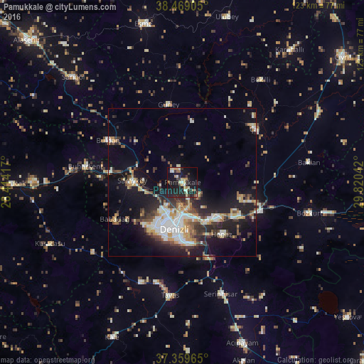
Analysis of Pamukkale night lights 2016
Square area 10x10 km:
 0.65%
0.65%90-99
5.19%80-89
3.9%70-79
4.38%60-69
3.41%50-59
2.11%40-49
2.76%30-39
4.06%20-29
13.47%10-19
42.21%0-9
17.86%Square area 50x50 km:
2.56%90-99
3.92%80-89
1.8%70-79
2.4%60-69
1.89%50-59
1.99%40-49
2.52%30-39
3.55%20-29
5.39%10-19
12.72%0-9
61.27%Clear (daylight) street map image can be seen on geolist.org.
Map coordinates:
38° 28' 8.6" North, 28° 24' 51" East
37° 54' 59.2" North, 29° 7' 2.2" East
37° 21' 34.7" North, 29° 49' 13.5" East
Some cities around Pamukkale sort by population:
• Denizli
16 km =9.9 mi,  189°
189°
• Merkezefendi
14 km =8.7 mi,  208°
208°
• Sarayköy
16.9 km =10.5 mi,  273°
273°
• Serinhisar
39.5 km =24.5 mi,  160°
160°
• Buldan
28.9 km =18 mi,  299°
299°
• Tavas
38.4 km =23.9 mi, 186°
• Honaz
22.2 km =13.8 mi,  142°
142°
• Buharkent
33.3 km =20.7 mi,  279°
279°
302903 (p: 10,000)
Sources (retrieved 2019-11-25):
» Earth at Night: Flat Maps 2012, 2016