Samsat night lights from space
Night Light of Samsat (Adıyaman) from space (Turkey) Src. Average luminocity for 10x10km area is 6.3929% and for 50x50km: 7.0016%.
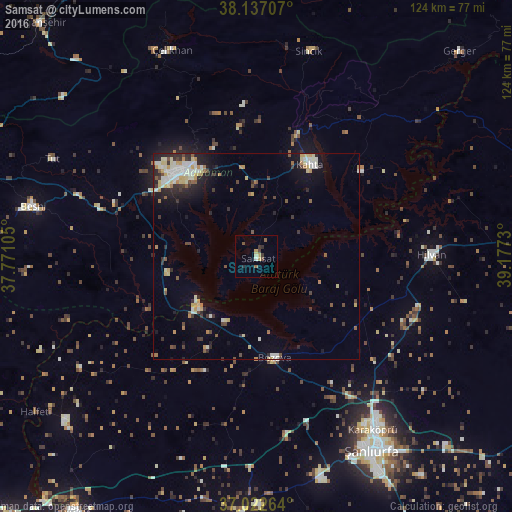
Analysis of Samsat night lights 2016
Square area 10x10 km:
 0.34%
0.34%90-99
0.34%80-89
1.02%70-79
1.7%60-69
0%50-59
1.87%40-49
1.02%30-39
1.87%20-29
1.36%10-19
0%0-9
90.48%Square area 50x50 km:
0.85%90-99
1.4%80-89
1.13%70-79
0.82%60-69
0.52%50-59
0.8%40-49
0.77%30-39
1.06%20-29
1.7%10-19
3.11%0-9
87.84%Clear (daylight) street map image can be seen on geolist.org.
Map coordinates:
38° 8' 13.5" North, 37° 46' 15.8" East
37° 34' 55" North, 38° 28' 27" East
37° 1' 21.5" North, 39° 10' 38.3" East
Some cities around Samsat sort by population:
• Şanlıurfa
54.1 km =33.6 mi,  148°
148°
• Adıyaman
26.7 km =16.6 mi,  319°
319°
• Kâhta
26.2 km =16.3 mi,  30°
30°
• Bozova
24.8 km =15.4 mi,  169°
169°
• Hilvan
42.4 km =26.3 mi,  89°
89°
• Çelikhan
53.6 km =33.3 mi,  337°
337°
• Tut
54.5 km =33.9 mi,  295°
295°
• Sincik
52 km =32.3 mi,  13°
13°
301943 (p: 9,308)
Sources (retrieved 2019-11-25):
» Earth at Night: Flat Maps 2012, 2016