Özalp night lights from space
Night Light of Özalp (Van) from space (Turkey) Src. Average luminocity for 10x10km area is 5.9253% and for 50x50km: 0.6096%.
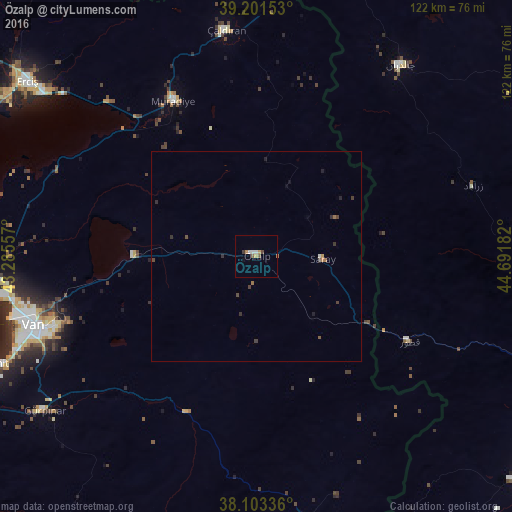
Analysis of Özalp night lights 2016
Square area 10x10 km:
 0.65%
0.65%90-99
1.3%80-89
0%70-79
1.46%60-69
0.81%50-59
0.97%40-49
0.97%30-39
0.65%20-29
0%10-19
0.32%0-9
92.86%Square area 50x50 km:
0.03%90-99
0.08%80-89
0%70-79
0.09%60-69
0.15%50-59
0.07%40-49
0.18%30-39
0.19%20-29
0.15%10-19
0.11%0-9
98.95%Clear (daylight) street map image can be seen on geolist.org.
Map coordinates:
39° 12' 5.5" North, 43° 17' 8.1" East
38° 39' 16.4" North, 43° 59' 19.3" East
38° 6' 12.1" North, 44° 41' 30.6" East
Some cities around Özalp sort by population:
• Van
55.6 km =34.5 mi,  251°
251°
• Khowy, IR
84.5 km =52.5 mi,  97°
97°
• Erciş
68.4 km =42.5 mi,  307°
307°
• Salmās, IR
84.6 km =52.6 mi,  126°
126°
• Qarah Ẕīā’ od Dīn, IR
93.7 km =58.2 mi,  73°
73°
• Başkale
67.8 km =42.1 mi,  177°
177°
• Gevaş
87.1 km =54.1 mi,  242°
242°
• Edremit
68.6 km =42.6 mi, 247°
303022 (p: 8,249)
Sources (retrieved 2019-11-25):
» Earth at Night: Flat Maps 2012, 2016