Koçarlı night lights from space
Night Light of Koçarlı (Aydın) from space (Turkey) Src. Average luminocity for 10x10km area is 15.0901% and for 50x50km: 12.9536%.
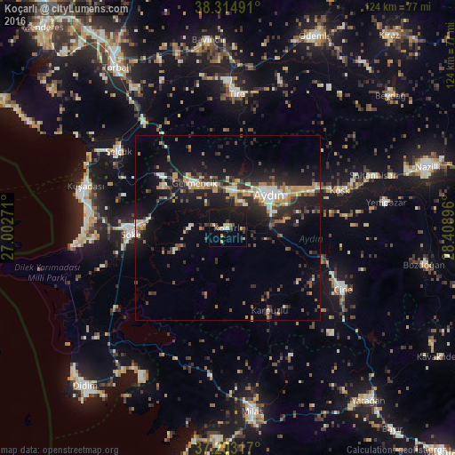
Analysis of Koçarlı night lights 2016
Square area 10x10 km:
100  0.34%
0.34%
90-99 1.36%
80-89 2.38%
70-79 2.89%
60-69 1.19%
50-59 0.34%
40-49 3.74%
30-39 1.7%
20-29 0.85%
10-19 18.54%
0-9 66.67%
0.34%90-99
1.36%80-89
2.38%70-79
2.89%60-69
1.19%50-59
0.34%40-49
3.74%30-39
1.7%20-29
0.85%10-19
18.54%0-9
66.67%Square area 50x50 km:
100 1.02%
90-99 1.95%
80-89 1.16%
70-79 2.1%
60-69 1.5%
50-59 1.18%
40-49 2.11%
30-39 2.37%
20-29 4.52%
10-19 11.38%
0-9 70.7%
1.02%90-99
1.95%80-89
1.16%70-79
2.1%60-69
1.5%50-59
1.18%40-49
2.11%30-39
2.37%20-29
4.52%10-19
11.38%0-9
70.7%Clear (daylight) street map image can be seen on geolist.org.
Map coordinates:
38° 18' 53.7" North, 27° 0' 9.8" East
37° 45' 40.1" North, 27° 42' 21" East
37° 12' 11.4" North, 28° 24' 32.3" East
Some cities around Koçarlı sort by population:
• Aydın
15 km =9.3 mi,  51°
51°
• Söke
26.4 km =16.4 mi,  266°
266°
• Çine
35.2 km =21.9 mi,  117°
117°
• İncirliova
10.2 km =6.3 mi,  8°
8°
• Germencik
15.2 km =9.4 mi,  323°
323°
• Acarlar
7.9 km =4.9 mi,  27°
27°
• Köşk
32.1 km =19.9 mi,  71°
71°
• Davutlar
36.4 km =22.6 mi, 265°
306908 (p: 8,594)
Sources (retrieved 2019-11-25):
» Earth at Night: Flat Maps 2012, 2016