Yatağan night lights from space
Night Light of Yatağan (Muğla) from space (Turkey) Src. Average luminocity for 10x10km area is 33.3604% and for 50x50km: 9.7089%.
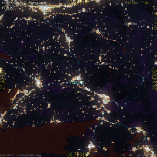
Analysis of Yatağan night lights 2016
Square area 10x10 km:
100  2.44%
2.44%
90-99 7.63%
80-89 4.87%
70-79 5.03%
60-69 3.9%
50-59 1.3%
40-49 1.79%
30-39 8.44%
20-29 6.17%
10-19 47.89%
0-9 10.55%
2.44%90-99
7.63%80-89
4.87%70-79
5.03%60-69
3.9%50-59
1.3%40-49
1.79%30-39
8.44%20-29
6.17%10-19
47.89%0-9
10.55%Square area 50x50 km:
100 0.42%
90-99 2.02%
80-89 0.98%
70-79 1.19%
60-69 1.12%
50-59 1.01%
40-49 1.36%
30-39 1.99%
20-29 2.63%
10-19 8.23%
0-9 79.04%
0.42%90-99
2.02%80-89
0.98%70-79
1.19%60-69
1.12%50-59
1.01%40-49
1.36%30-39
1.99%20-29
2.63%10-19
8.23%0-9
79.04%Clear (daylight) street map image can be seen on geolist.org.
Map coordinates:
37° 53' 49.8" North, 27° 26' 22.8" East
37° 20' 24.9" North, 28° 8' 34" East
36° 46' 45" North, 28° 50' 45.3" East
Some cities around Yatağan sort by population:
• Muğla
24 km =14.9 mi,  124°
124°
• Milas
31.8 km =19.8 mi,  265°
265°
• Marmaris
55.2 km =34.3 mi,  167°
167°
• Çine
31.2 km =19.4 mi,  346°
346°
• Köşk
57.6 km =35.8 mi, 351°
• Bozdoğan
39.8 km =24.7 mi,  22°
22°
• Yenipazar
53.9 km =33.5 mi,  4°
4°
• Ula
35.7 km =22.2 mi,  137°
137°
297564 (p: 19,020)
Sources (retrieved 2019-11-25):
» Earth at Night: Flat Maps 2012, 2016